https://ae.trip.com/moments/poi-meishajian-45198174
2.5
4.8/5
12條評論
Mountain climbing
Meishajian is located in Yantian Street. Meishajian has sharp peaks and alternating mountains and rivers. At this time, the scenery is simple, clean and beautiful. Its mountain range is continuous, and its hilltops include Egongji with an altitude of 619 meters, Yuanshan with an altitude of 599 meters, and Dawangding with an altitude of 553 meters.
Meishajian的地址:
Meishajian, Yantian, Shenzhen, China
Meishajian的推薦遊覽時間:
0.5-1 day
Meishajian的門票價格
免費入場
Hike with views to die for
Mei sha jian is a beautiful hike with sweeping ocean views located in the Yantian area.
The hike is pretty much all stairs, with periods of flat paved path in between. The stairs are steep and at times can smash the knees up. But the views are most definitely worth it.
You can see the Dameisha beach, ocean, and the Yantian cargo port (hugely impressive)
You can also see OCT EAST in detail with the train and the European style buildings as well as Longgang centre in the distance. With the wind blowing this is an incredible feeling.
What I like about this hike is the flora and fauna. It has a different feeling to some of the other mountains in SZ. The path is well signposted with only a few directions possible to take so getting lost here would be difficult. Head to the peak to get the best views and lots of pics.
I suggest going back down the way you came and end at Yantian Customs base. You can get a taxi from there back to the metro. When you get to the top you can see a long path of stairs below you, follow this to get onto the greenway and onto the highway
Start at Yantian road metro (line 8) and get a taxi this location. Follow the sign up to the top. After you have finished you can end at OCT EAST and get a taxi. Type this into map or into didi 山海大观观景台
No water on the trail bring enough
Its exposed to a lot of sunshine so bring sunscreen
#staycation#urbanexplorer#summervacation#nationalpark#awesomepic#naturalwonders
Joe0412
89
From Meisha Peak to Yunhai Park
Today, although the sun wasn't shining brightly, it was a perfect day for hiking. I heard that the summit project of Meisha Peak has been completed, so I decided to fulfill my previous unaccomplished wish and set off.
I took Metro Line 8 to Yantian Road and then transferred to the Yunhai Park C-line bus, which directly brought me to the Meisha Peak hiking entrance. Climbing step by step, with occasional breaks, it took about an hour to reach the summit. The 360-degree view from the observation deck was stunning, offering a panoramic view of Yantian Port and the Eastern Overseas Chinese Town. The Cuijing Reservoir, Honghua Reservoir, and the upper reservoir of the pumped-storage power station lay quietly amidst the mountains, creating a picturesque scene of lush greenery and clear waters.
Descending via the stone steps on the other side towards Yunhai Park, I discovered that the scenery on this route was even more breathtaking. I frequently turned back to admire the majestic silhouette of Meisha Peak. From certain angles, the observation deck of Meisha Peak looked quite futuristic.
The Mountain-Sea Library in Yunhai Park features simple and modern architectural lines, exuding a contemporary vibe. From here, you can gaze at the sea and mountains below. Sitting down with a cup of coffee and a book truly feels like a literary retreat.
After a good rest, I took the Yunhai Park C-line bus back down the mountain.
陌上行
Meet the beautiful sunrise on the top of Meisha Peak#
#ShenzhenAttractions
In Shenzhen, the sunrise at Meishajian is a romantic spectacle not to be missed.
We climbed up Meisha Peak in the early morning. The mountain breeze was cool and the night was still dark. In the distance where the sea and the sky meet, a hint of paleness gradually appears. As time went by, the white turned to light pink and then to golden yellow.
In an instant, the edge of the sun jumped out of the sea level, emitting thousands of golden rays, dyeing the sky and the sea into brilliant colors. The clouds are rimmed with gold, as gorgeous as brocade. The light shines through the mountains and forests, awakening the sleeping world.
Standing on the top of the mountain, bathing in the morning sun, feeling the warmth and hope. The sunrise at Meishajian is a gift from nature. It makes people intoxicated and makes them embrace the passion for life again.
小田子
Hiking Route Guide to Meishajian Peak!
Experience a deep dialogue between humanity and nature,
ascend to the city viewing platform atop Meishajian Peak,
enjoy a 360° view of Shenzhen's mountains and seas,
overlook the entire Yantian landscape, take a deep breath,
Dameisha, Xiaomeisha, and Sanzhouti Reservoir are all in sight,
a magnificent and breathtaking scenery.
⛰️ Shenzhen's fourth highest peak - Meishajian
✅ Highest altitude: 753 meters
▪️ Our chosen route:
🌳 Entrance: Gengzi Shouyi Sculpture Park entrance (you can see the Sanzhouti Country Trail sign, refer to Figure 4)
🚌 Drop-off point: Exit A1 of Yantian Port West Station on Lines 2/8, transfer to Yunhai Special Line A and get off at Gengzi Shouyi Sculpture Park, the entrance is across the street
🌳 Exit: Shanhai Daguan direction
🚇 Nearest subway: Line 8 Yantianxu Station
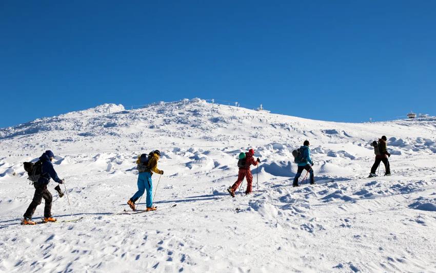
▫️ I haven't hiked here before because the Meishajian viewing platform ⚠️ was under maintenance and closed to the public. Last Saturday, a group of five of us finally checked this place out!
▪️ The recent weather is perfect for outdoor hiking, and the Sanzhouti Country Trail is really crowded.
▫️ The entire route up and down the mountain is steps, but fortunately, the route is not long, and there are many shaded areas along the way.
▪️ There are almost no forks along the way, just follow the entrance and you'll be fine. There is a restroom 🚻 near the top of the mountain, which is also very crowded.
▫️⚠️ It took us about 5 hours to go up and down the mountain, including a long rest ➕ after descending to Shanhai Daguan, we didn't take the bus but walked 8 kilometers along the greenway (which is also a driveway) to the subway station. It is not recommended to walk to the subway station like we did, as there is too much traffic on this greenway and it is not safe. It is recommended to take the Yunhai Special Line from Shanhai Daguan to the subway station.
Liam.Bell.39
Shenzhen Subway: Directly to 30,000 Blooming Cherry Blossoms!
Shenzhen's largest cherry blossom forest! The entire valley hides a vast sea of cherry blossoms, reviving across the mountains and fields. From a distance, the layers upon layers resemble mounds of snow.
🕰Flowering Season: Every year from February–March
📍Location: Zuiying Pavilion, Xiaosanzhoutian, Yantian District
🚗Transportation:
Self-drive + Walking: Navigate to "Sun Yat-sen Gengzi Uprising Sculpture Park." Pass by this location but do not stop. Continue driving along the mountain road to the gatehouse. Park on the left side of the road, and the cherry blossom forest is right there.
❤️Tips:
🌸The lighting in the afternoon is excellent; wearing light-colored clothing will make for stunning photos.
🌸Meishajian Peak can be reached in 30 mins; wear comfortable, non-slip shoes.
🌸The flowers near Zuiying Pavilion bloom particularly well, making for superb photos.
🌸Bring plenty of water, dry food, and snacks to replenish your energy. You can also have a picnic in the cherry blossom forest, which is very pleasant.
🌸Xiaosanzhou has planted many cherry blossoms of various varieties.
Echo~Foster

Recommended Themes

2025 Recommended Attractions in Meishajian (Updated April)
18 posts

2025 Recommended Guides in Meishajian (Updated April)
14 posts
2025 Recommended Mountain Climbing in Meishajian (Updated April)
10 posts
Spring Outing on Yantian Greenway: Meishajian
Meishajian is the third highest peak in Shenzhen, located east of Wutong Mountain. Since there is a bus that can take you to Xiaosanzhoutang, it is relatively easy to reach the summit from the southeast corner. However, there seems to be some construction work at the highest point early this year, so those who wish to reach the summit should stay updated on the latest situation. If you don't plan to reach the summit, you can still take spring-exclusive photos of cherry blossoms with Meishajian in the background from the west side of Xiaosanzhoutang.
hk_traveller_hk
Summer Exclusive! Explore the Beautiful Scenery of Meishajian, Shenzhen!
Hey friends, today I want to recommend a beautiful and niche attraction I recently discovered - Meishajian in Yantian District, Shenzhen. I heard that many people don't know about this place yet, so come and explore it with me!
Address: Near Meisha Subdistrict Office, next to OCT East, Yantian District, Shenzhen
Opening hours: Open all day (but try to avoid the weekend crowds)
Weather guide: In the hot summer, of course, you need a cool trip! Bring sunglasses and a sun hat, and take sun protection measures to better enjoy the sun and nature!
Photography tips: If you want to take beautiful photos, be sure to climb to the top of the mountain and overlook the entire coastline! The scenery there will definitely amaze you! Also, don't forget to bring a camera or a phone tripod for clearer photos!
Grace*fancy
Meishajian is the best place to go hiking in Shenzhen.
Conquered! Meishajian, Shenzhen!
The sea of clouds and sunset are so beautiful!
🥹
The scenery along the way is so beautiful that it feels like being at Chaka Salt Lake.
Low difficulty, short time, large shaded area
1-hour route to the top:
🔍Shanhai Daguang Observation Deck, no parking lot 🅿️ park on the roadside
⚠️There is a wc🚻 on the left side of the entrance, go once, there is none on the mountain
🥤Prepare a few bottles of water, there is none on the mountain
The road is easy to walk, with stone steps and gravel roads, not steep~
🌿
We chose the more comfortable Shanhai Daguang route among the three routes to the top.
1. Shanhai Daguang
2. Tea Valley Trailhead
3. Yantian Checkpoint Trailhead
3m.ly @d@m$
[Meishajian Hiking] 11.2 kilometers to challenge your knees, get ready for the stairs
#hiking
I tell you important things three times three times, this is a 700 meters high stairs challenge, the return trip is also on the 700 meters stairs down the mountain, after returning home my knees are useless, the first trip after the descent is not to eat, but to go to the massage parlor.
Hiking route in Meishajian, Shenzhen, start from Liantang Port, take the subway to Salt Field Road Station, and then start climbing. The total distance is about 11.2 kilometers, takes about 4.5 hours, and the total climb reaches 1013 meters. The route passes through beautiful attractions such as Cui Ling Reservoir and Red Flower Reservoir, eventually reaching the 753-meter-high Mei Sha Peak, overlooking the magnificent eastern sea view.
Hikers need to be physically prepared, especially the initial stairs and uphill sections, and it is recommended to wear sneakers and carry adequate water and sunscreen. The route instructions are clear and suitable for most hiking enthusiasts. In addition to the natural scenery, the route also combines cityscapes, making the entire trip full of variety and interest.
#globaltravel #hiking #hiking route recommendation #Shenzhen
worldtravellover
How can you come to Shenzhen without climbing mountains and seeing the sea?
Shenzhen is a coastal city.
The sea view resources are very rich
There are many mountaineering enthusiasts in this city.
So each park and hiking trail is relatively mature.
When you come to Shenzhen, you must try hiking between the mountains and the sea
.
This time I'm sharing 📍Meishajian
Take a taxi to "Shanhai Grand View" and you can see the starting point of the trail
The route is relatively clear and it takes about 1 hour to reach the summit.
High visibility in clear weather
You can also see Hong Kong from a distance
.
AlaricSolstice234=
Discovering Nature's Wonders: Meisha Tip in Shenzhen, the most beautiful mountain climbing experience
🧗♀️ Meisha Tip, the third highest peak in Shenzhen with an altitude of 753 meters, offers stunning views along the climb. You can gaze afar at Wutong Mountain and Dameisha, overlook Yantian Port and Xiaosanzhou Reservoir, and have a panoramic view of the Eastern Overseas Chinese Town at sunset🌄.
🚇 Transportation:
1️⃣ Yantian Checkpoint Trailhead: Take the Metro Line 8 to "Yantian Road" station, exit E, and walk to "Yantian Public Security Sub-bureau Patrol Police Brigade Special Duty Squad" to reach the trailhead.
2️⃣ Chaxigu Trailhead: Take the Eastern Overseas Chinese Town 909 shuttle bus to the final stop "Ketragen Hotel", walk forward 50 meters to reach the trailhead; or drive to "Chaxigu Parking Lot", where roadside parking is also available, then walk to the trailhead.
3️⃣ Shanhai Daguan Trailhead: Accessible only by car, navigate to "Shanhai Daguan Viewing Platform", continue forward 50 meters past the sign "Such a Lovely Land" to find the trailhead. Note that parking is prohibited🈲 here, so park your car at the nearby Dahua Xing Temple parking lot and walk about 2 kilometers to the trailhead.
🧭 Routes:
1️⃣ Yantian Checkpoint Trailhead: This trailhead is directly accessible by metro, with a one-way distance of 10 kilometers, taking about 4 hours, and is the longest in duration.
2️⃣ Chaxigu Trailhead: Directly accessible by bus, with a one-way distance of 3 kilometers, taking about 1.5 to 2 hours.
3️⃣ Shanhai Daguan Trailhead: This trailhead offers the quickest route, taking about 1 to 1.5 hours one-way, and has the best scenery. It is recommended for friends who drive to choose this route, which also has a free parking lot and the only restroom🚻.
🍔Essential Items:
Mosquito repellent, 2 to 3 bottles of mineral water, snacks, light jacket.
⏰Recommended visiting time: 3 to 6 hours.
💕Important Notes:
1️⃣ There are no restrooms along the entire route, nor places to buy water, so be prepared in advance.
2️⃣ It is advised to carry a trash bag to keep the environment clean.
🌈That's the detailed hiking guide for Meisha Tip in Shenzhen. Remember to save it and let's go hiking together this weekend!💪
catchairport
Meisha Tip in Shenzhen, Summit Climbing Guide
The mountain is super beautiful! Go check it out this weekend!
Meisha Tip, located in Yantian Street, Yantian District, Shenzhen, has an altitude of 753 meters and is the third highest peak in Shenzhen. Climbing to the top is an excellent travel experience.
⛰ Destination: Meisha Tip Summit
📈 Route Trajectory: Mountain and Sea Panorama—Meisha Tip—Sun Yat-sen Gengzi Uprising Sculpture Park (Total 4.5 kilometers)
⏰ Total Time: 5 hours (The climb is not very difficult, but the summit is worth staying for a long time)
🚗 Navigation: Sun Yat-sen Gengzi Uprising Sculpture Park
🚶 Route Guide:
1. Navigate to Sun Yat-sen Gengzi Uprising Sculpture Park and park your car (no fine for roadside parking), then take a taxi to the Mountain and Sea Panorama trailhead (there is only one scenic platform toilet on the way, no supply and handwashing facilities during the climb). The entire tour is on footpaths (it is recommended to observe the weather in advance, you can overlook beautiful views such as the full panorama of Yantian Port, Dameisha, and the mountain trail known as the most beautiful sky ladder).
2. After a short rest at the summit, go down the other side, keep walking forward, and you will see road signs, one side is Tanxian Ancient Temple, and the other is the direction of Chaxi Valley, choose the direction of Chaxi Valley, keep walking until you reach Sun Yat-sen Gengzi Uprising Sculpture Park (visitors can learn about related history and culture here, play in the water, and more importantly, enjoy toilet services 😹).
📢 Essentials for Climbing:
1. Food: It is recommended to bring bread, biscuits, chocolate, steamed buns (for quick energy replenishment); pickles, cured meat, etc. (to replenish lost salts).
2. Drinking water: Prepare two 500ml bottles of mineral water (it is recommended to carry an additional bottle of Pocari Sweat or a functional drink for emergencies), especially to replenish fluids in hot weather.
3. Sports shoes: A pair of ordinary sports shoes is enough to cope with the climbing route.
4. Fruits: Prepare bananas, cherry tomatoes, cucumbers, and other fruits for supply.
5. Others: It is recommended to carry Huoxiang Zhengqi liquid (to prevent heatstroke), and mosquito repellent (because there are relatively more mosquitoes).
RAYMOND WALSH
Meisha Tip is just so beautiful! Why didn't anyone tell me earlier
【Hiking Routes】
There are three main trailheads:
1⃣️ Yantian Checkpoint Trailhead: Navigate to "Yantian Public Security Sub-bureau Patrol Police Brigade Special Duty Squad" to start the hike. Although this route is the longest and takes more time, the scenery along the way is beautiful and worth a try!
2⃣️ Chaxi Valley Trailhead: Navigate to Sun Yat-sen's Gengzi Uprising Sculpture Park and walk back 50 meters to start the hike. This is the only trailhead accessible by public bus. Take the Eastern Overseas Chinese Town 909 minibus and get off at the Laitragen Hotel.
3⃣️ Mountain and Sea View Trailhead: Navigate to the Mountain and Sea View Observation Deck. This is the fastest route to the summit and the one I took on this trip, more details on the strategy will follow.
【Hiking Strategy】
⭐️ Mountain and Sea View Route:
✨ Trailhead: After arriving at the Mountain and Sea View Observation Deck, you will see a sign that says "Such a Lovely Land" and walk forward 50 meters to find an inconspicuous trailhead. This route takes 1-1.5 hours, with medium difficulty, and consists entirely of steps.
🌄 Sunset Viewing Timing: It is recommended to arrive at the trailhead around 4:30 PM, reach the summit around 6 PM, and enjoy the sunset at 6:30 PM. If you like taking photos, you may want to reserve an extra half hour. You can check the weather forecast and plan to start 1.5-2 hours earlier.
🍔 Carry Snacks: It is suggested to bring some small bread or biscuits, and 1 liter of water (drink less because there are no toilets).
🌞 Remember Sun Protection: There is shade at the beginning, but almost no cover in the latter half. In addition to a hat and sunglasses, you can also carry a lightweight umbrella (it's not very windy up there).
【Descent Routes】
You can choose from the following three routes:
Option 1⃣️: Descend via the stone steps on the same route, which is the shortest in time. However, be sure to turn on a flashlight after dark for safety.
Option 2⃣️: Towards the reservoir direction (Chaxi Valley). If you want to watch the sunset, it is not recommended to take this route down, as the stairs are steep and the visibility is relatively dark, which is not very safe. After descending, you can take a taxi at Yantian Road subway station.
Option 3⃣️: Towards the reservoir direction (longer road name). The latter half of this route is all on a big road, taking about 1 hour in total, and is more comfortable to walk, but it is quite far. The lowest point is the Laitragen Hotel (where cars can be parked).
caeryn_6476
Shenzhen Shifeng | Mount Meisha Tip
Mount Meisha Tip is named for its peak resembling a sharp cone, located among the mountains of Sanzhoutian in Yantian District, Shenzhen. It is the third highest mountain in Shenzhen, with the Eastern Overseas Chinese Town on the left, Wutong Mountain on the right, the Yuanshan Scenic Area behind, and Yantian Port and Dameisha in front. Climbing to the top of Meisha Tip offers a view of both mountains and sea!
🗓 Itinerary:
Sun Yat-sen's Gengzi Uprising Sculpture Park Trailhead (most recommended classic route)
Mountain and Sea Grand View Viewing Platform Trailhead (shortest distance route)
Yantian Checkpoint Trailhead (longest distance but easiest route)
Yantian Water Plant Trailhead
Tanxian Temple Trailhead
Mountain and Sea Grand View Viewing Platform Trailhead (2021.3.17)
You can park at the trailhead parking lot if driving. The round trip up and down the mountain takes 3 hours (if a landslide has closed the road and cars can't enter the parking lot, it is recommended to park in the nearby residential or villa area and then walk a few hundred meters to reach the trailhead.
Gengzi Uprising Sculpture Park Trailhead (2022.05.03)
You can park at the Chaxi Valley parking lot if driving, 5 yuan/hour + 3 yuan/hour. The round trip up and down the mountain takes 4 hours. It is suggested to stay at the summit until sunset to descend, as the sunset glow gives the scenery a thin veil of light.
🚉 Transportation Tips:
If not driving, it is recommended to enter from the Mountain and Sea Grand View Viewing Platform and exit from the Gengzi Uprising Trailhead (so you can take different routes and see different scenery) (of course, you can choose the route according to your own physical fitness and preferences).
CADENCE MCKINNEY
Climbing Shenzhen Tianti Meishajian, a good place for holiday hiking
Cross the mountains and go to the sea of clouds together☁️
Meishajian is the third highest peak in Shenzhen⛰
753 meters above sea level
Even during holidays, there are few people, it is quiet, and no one will disturb you no matter how you take photos😂
Beautiful mountain view
If there are a lot of clouds, you can also experience the feeling of being in the sea of clouds☁️
There are three trailheads to climb Meishajian, and the time required for different trailheads is also different⬇️⬇️⬇️
①Chaxi Valley Trailhead🚏
👍The most convenient entrance to the mountain
🚌You can take the bus directly to the mountain trail, and take the 909 minibus from OCT East to the Interlaken Hotel. It is said to be 15 yuan per person (bus cards cannot be used, but WeChat and Alipay can be used). Queue up to get on the bus and leave when it is full. After getting off the bus, walk forward and you will find the entrance to the hiking trail on your left.
⏰The whole journey is about 2.3 kilometers and takes 1-1.5 hours
②Shanhai Grand View Trailhead🚏
👍The trailhead closest to the summit, with the best views
🚗There is no bus, you can only drive or take a taxi, navigate to the Shanhai Grand View Observation Deck, there is a free parking lot and the only toilet
⏰It only takes 1-1.5 hours to reach the top, and the scenery along the way is the best of the three routes.
③Yantian Checkpoint Trailhead🚏
👍The road is the easiest to walk, but the route is the longest
🚞Take Line 8 to Exit E of Yantian Road Station. It is still several kilometers away from the mountain trail. Navigate to the Special Service Squadron of the Patrol Brigade of the Yantian Public Security Bureau, and then walk along the greenway to the entrance of the Yantian Checkpoint.
⏰From the entrance to the hiking trail, it is about 7 kilometers, which is suitable for cycling enthusiasts; the hiking trail to the peak of Meishajian is about 2 kilometers, which takes 40 minutes to 1 hour.
We took the third route, which was the longest. After getting out of the subway, we followed the navigation and rode our bikes for 20 minutes. We could see the uphill road. Because it was all uphill, it was not recommended for non-professional cyclists. We parked our bikes and walked up.
From here you still have to walk a distance to reach the greenway of the scenic area. After entering, you can follow the instructions or follow the navigation. It took about 1.5 hours to reach the trailhead.
Because the scenic area prohibits foreign vehicles, the greenway is less crowded and has few cars, making it very quiet.
After reaching the trailhead, we walked all the way to the top of the mountain. It took about ⏰ 40 minutes. There were signs for wild boars on the way up the mountain. I asked other people and they said that wild boars usually don’t come out to forage during the day, so we can go up safely.
This hiking trail has the fewest steps and the environment is beautiful.
After reaching the top of the mountain, I didn’t stop to watch the sunset. It is said that the sunset is also very beautiful.
In summary, it is quiet and suitable for quiet mountain climbing.
⭕️Tips
1⃣ The greenway on route ③ is very sunny, so be sure to take sunscreen
2⃣There are many mosquitoes on the mountain, so anti-mosquito measures are needed
3⃣ You don’t need to bring too much water. There are boxes of water placed along the way. Scan the code and pay 5 yuan per bottle.
4⃣ Be sure to replenish water at the trailhead, as there is no water for sale on the mountain
If you can't walk on the greenway of route ③, you can call a motorcycle to take you there.
CuriousVoyager
Spring is in full swing, everything is reviving, climb up to Meisha Peak and feel the ups and downs of the ladder of love!
Spring is in full swing, everything is reviving, climb up to Meisha Peak and feel the ups and downs of the ladder of love!
The top of Meisha Peak has a wide view and is a 360-degree natural viewing platform, overlooking the Sanzhoutian Reservoir, Hongli Reservoir, Chaxi Valley, Yantian Port and Meisha, with unobstructed views of the mountains and sea!
It passes through Yantian North Comprehensive Parking Lot, Railway Bridge, Cuiling Reservoir, Xiaosanzhoutang South Gate 1 and other places, and finally reaches the top of Meishajian Mountain. The whole journey is about 10+ kilometers, with a maximum climb of 700+ meters and takes about 5 hours. It is suitable for people with some hiking experience. The difficulty is moderate, and you can exercise your body while enjoying the beautiful scenery. It is definitely an unforgettable hiking trip!
Come and hike and feel the charm of nature together! Remember to follow me.
Elijah.Butler@73
It's not that Wutong Mountain is not worth climbing, but that Meisha Tip offers better value for money! (Guide Edition)
Meisha Tip Mountain Climbing Route Guide
Meisha Mountain Cloud Sea Plaza, built on the hillside of Meisha Mountain, is the highest library in Shenzhen, and also the best viewing platform overlooking the mountains and sea of Yantian, Shenzhen. It is a good place to climb mountains and see the sea in Shenzhen, and one of the best places for hiking in Shenzhen. It is currently in a trial operation state and does not require a ticket. It is open to the public for free.
The fastest climbing route to the Cloud Sea Plaza only takes 30 minutes to reach, and the whole journey is a mountain climbing trail, to avoid getting lost, remember to bookmark it for those who have not been there yet!
Subway: Get off at Yantian Port West Station, choose B2 or A2 exit to transfer to Seafood Street Bus Station (2). Remember, it is Seafood Street Bus Station (2), there are multiple platforms at Seafood Street Bus Station, and they are far apart!
Bus🚌: Seafood Street Bus Station (2)
Self-driving🚗: Seafood Street Parking Lot
There is a special line to the Cloud Sea on weekends, 15/person, the boarding point is Yantian Port West Subway Station, Haishan Subway Station.
Starting from the bus station, you can reach the Spring Sea Library in about 100 meters. Cross the zebra crossing from the entrance of the library to the opposite side.
agitated.deeanna
40
Post
更多推薦
Trending Travelogues
Kiki Beach Resort Batam: A tropical paradise in Indonesia | India Public Holidays in the Year of the Rabbit 2025 | Thailand public holidays in the Year of the Rabbit 2023 | 2025 An ultimate guide to Legoland Malaysia: A fun paradise for all ages | All you need to know before you go: Hong Kong entry requirements | Romantic destinations for Valentine’s Day in 2025 | NANJING, China Travel Guide - Best Things to Do & Travel Tips | Hong Kong Travel Guide: What to SEE, DO & EAT in HONG KONG | Suzhou Travel Guide 2022 | 5 best places to travel during your time in Sentosa Island, Singapore | 9 Things to Know Before Visiting Los Angeles | Japan entry requirements: Can I travel to Japan? | Sanya Travel Guide | 10 of the best things to do in Sanya, Hainan | JR Pass: All You Need to Know About Travel in Japan | Hong Kong public holidays in the Year of the Rabbit 2023 | All you need to know before you go: UK entry requirements | Hari Raya Aidilfitri 2023: Traditions and customs of the festival | Malaysia public holidays in the Year of the Rabbit 2025 | 2025 Cherry blossoms in Japan: A big feast for the eyes | All you need to know before you go: South Korea entry requirements | All you need to know before you go: Malaysia entry requirements | All you need to know before you go: Canada entry requirements | South Korea public holidays in the Year of the Rabbit 2025 | Top 10 places to view beautiful cherry blossoms across the globe 2025 | Top 15 tourist attractions you can't miss in Shanghai | 2025 Shenzhen travel | Where To Stay, Eat & Explore | 2025 Guangzhou Travel Guide: Plan Your Travel To Guangzhou | Xi’an Travel Guide: Best Things To Do in Xi’an, China | 2025 Chengdu Travel Guide - Best Things to do in Chengdu | Shanghai Travel Guide: What to Know Before You Visit Shanghai
Recommended Attractions at Popular Destinations
Bangkok attraction near me | Manila attraction near me | Tokyo attraction near me | Taipei attraction near me | Hong Kong attraction near me | Seoul attraction near me | Kuala Lumpur attraction near me | Los Angeles attraction near me | Shanghai attraction near me | New York attraction near me | Shenzhen attraction near me | Osaka attraction near me | Singapore attraction near me | London attraction near me | Guangzhou attraction near me | San Francisco attraction near me | Beijing attraction near me | Macau attraction near me | Bali attraction near me | Jakarta attraction near me | Paris attraction near me | Ho Chi Minh City attraction near me | Istanbul attraction near me | Phuket attraction near me | Chicago attraction near me | Seattle attraction near me | Toronto attraction near me | Orlando attraction near me | Cebu attraction near me | Chiang Mai attraction near me
Popular Ranked Lists
Popular Best Things to Do in Leye | Popular Premium Hotels in En Gev | Top 5 Best Things to Do in Jingxi | Popular Local Restaurants in Jincheng | Top 9 Local Restaurants in Lushan Global Geopark | Popular Best Things to Do in Wuzhishan | Popular Best Things to Do in Tongdao | Top 10 Local Restaurants in Genting Highlands | Top 10 Local Restaurants in Mudanjiang | Popular Best Things to Do in Yanyuan | Popular Best Things to Do in Shimian | Popular Luxury Hotels Near Fahaheel | Top 4 Best Things to Do in Mohe | Top 3 Local Restaurants in Hefeng | Top 10 Local Restaurants in Fuding | Popular Premium Hotels in Korcula | Top 5 Local Restaurants in Rugao | Popular Luxury Hotels Near Palakkad | Popular Local Restaurants in Wuyi | Popular Luxury Hotels Near Sandakan Division | Popular Luxury Hotels Near Kenmore | Top 10 Local Restaurants in Zhuzhou | Popular Best Things to Do in Lincang | Top 10 Local Restaurants in Kaohsiung | Top 8 Local Restaurants in Jiangyou | Top 10 Local Restaurants in Yushan | Top 10 Local Restaurants in Ningxiang | Top 4 Best Things to Do in Pyongyang | Top 8 Best Things to Do in Aksu Prefecture | Popular Luxury Hotels Near Kittila
Payment Methods
Our Partners
Copyright © 2025 Trip.com Travel Singapore Pte. Ltd. All rights reserved
Site Operator: Trip.com Travel Singapore Pte. Ltd.
Site Operator: Trip.com Travel Singapore Pte. Ltd.