https://ae.trip.com/moments/destination-qingzhou-898/
2025 Qingzhou Travel Guide: Must-see attractions, popular food, hotels, transportation routes (updated in May)
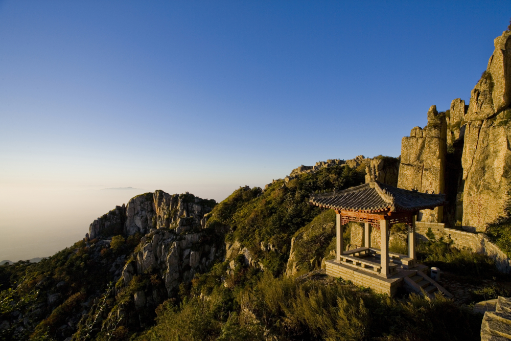
Qingzhou is located in the middle of the Shandong Peninsula. It is under the jurisdiction of Weifang City. It is one of the ancient Nine States. The southwestern suburbs outside the city have places such as the picturesque Yunmen Mountain, Camel Mountain, Linglong Mountain and Yangtian Mountain. Inside the city, there are sites such as the Fangong Pavilion (built to commemorate Fan Zhongyan of the Northern Song Dynasty), the Zhenjiao Temple (which was built in the Yuan Dynasty)m and the former site of the Qing Dynasty barracks. Qingzhou City is a National Historical and Cultural City and one of China's major flower distribution centers.
Qingzhou的今日天氣
Hazy 19-33℃

Qingzhou的熱門趨勢
Qingzhou的熱門Attraction
Ancient Town Tourist Area of Qingzhou China
(57)Qingzhou Museum
(33)Yunmen Mount Scenic Spots
(17)Jingtang Ancient Town
(9)Huanghua Creek
(8)All Moments About Qingzhou
Recommending 5 Underrated and Fun Cities
Reverse tourism is all the rage this year! Escaping the crowds and exploring hidden gem towns is the way to go~ These 5 underrated but amazing places hold the most healing travel memories of the past year, shared with those who also love off-the-beaten-path destinations 👇 --- 1️⃣ Qingzhou, Shandong | A Poetic Stay in a Millennia-Old City Recommended Reason: Qingzhou Ancient City is the "Pearl of Haidai," with well-preserved Ming and Qing Dynasty ancient streets and the Zen-like Ouyuan Garden. You can also visit the Qingzhou Museum, a national first-class museum, and experience the rich culture of Qilu. Best Months: April-May (cherry blossoms in full bloom), September-October (autumn scenery and ancient charm). Avoid the heat and cold, and stroll through the ancient city for a super relaxing experience! --- 2️⃣ Songyang, Lishui, Zhejiang | A Hidden Paradise in the Clouds Recommended Reason: Named "the last hidden paradise in Jiangnan" by *National Geographic*, the cliffside Chenjiapu Village, golden terraces, and Pioneer Bookstore are picturesque. Best Months: March-April (sea of rapeseed flowers), October-November (sun-drying harvest scenes). It's like a fairyland when shrouded in clouds and mist! --- 3️⃣ Chongzuo, Guangxi | Karst Wonders on the China-Vietnam Border Recommended Reason: Detian Transnational Waterfall spans China and Vietnam, and is magnificent during the rainy season. A bamboo raft drift in Mingshi Pastoral will make you feel like you've stepped into the fantasy world of *The Journey of Flower*. Best Months: June-August (waterfall at its fullest), November-December (golden rice paddies). Enjoy water activities in summer and idyllic scenery in autumn and winter~ --- 4️⃣ Handan, Hebei | The Underrated Hometown of Idioms Recommended Reason: The site of the ancient capital of the Zhao State during the Warring States period, the ancient city of Guangfu with its Tai Chi culture, and the birthplace of the idiom "Handan Xuebu" (imitating others blindly) are must-visits for history buffs! Best Months: April-May (spring scenery in the ancient city), September-October (crisp autumn air). Avoid the summer heat, and taking photos in Hanfu is super atmospheric! --- 5️⃣ Ninghai, Zhejiang | A Secluded Town Between Mountains and Sea Recommended Reason: Enjoy forest hot springs, the untouched Ming and Qing Dynasty architecture of Qiantong Ancient Town, and the breathtaking sunsets over the islands of Qiangjiao Town. Best Months: December-February (hot spring season), June-August (island tours). Soak in hot springs in winter and explore the coast in summer for maximum healing! --- 📝𝐓𝐢𝐩𝐬: - These small towns are easily accessible by car or high-speed rail + local car hire. - Prioritize unique homestays for accommodation, such as "Feiniaoji" in Songyang and "Shieryi" in Ninghai, for an immersive local experience. - Remember to bring your camera, as these places offer stunning photo opportunities everywhere! For your 2024 travels, there's no need to follow the crowds. Find your own sense of relaxation in these niche cities~💕LIBERTY INGRAM25Ancient Shandong....
Qingzhou Ancient City (青州古城) is conveniently located between both Ji'nan and Weifang, making it a good option for travelling to for a day trip. You can travel here by car or local bus, but the easiest option is to take a train and just get a taxi from the train station, taking around 15 minutes. Arriving at the majestic front gate, walk through the arch to the main street, where you can find restaurants, pavillions, gardens and temples. The small alleys all meet at the main street. It is very picturesque during the day or night, however it is usually busier in the evening when the buildings are lit up and there are also performances. Make sure you try the local delicacy, the meat bingze...it is a savory snack that is perfect to eat while walking around the attractions here. You can do all of the city In a just a couple of hours. This place is definitely worth a visit if you like old buildings and learning about local history. #2023travelwish #mytripvlog #tripblazersTheTravelShow6Humble Qingzhou
3rd tier cities are rarely the place tourists travel to in China. And understandably so. They're often less developed and less exciting versions of bigger cities. But in these cities reside a significant percentage of China's population and, therefore, they better reflect the country's culture. Qingzhou is one of such cities; a relatively insignificant city in modern China, but what few know is that it was quite an influential hub back in the day ... I mean WAY back in the day. Luckily some of the old town has survived (however obvious renovations are visible) and one can really imagine the good old days while navigating the little alleys. Of course it's inevitable that you will encounter the usual stores selling Sun Wu Kung face masks, milk tea, and trinkets from the early days of modern China, so don't expect any high end treasures. It might be better to just enjoy the walk, grab a bowl of noodles, and possibly get your hair trimmed outdoors by the local barbers that line the main street. Another charming part of the city is Yunmen Mountain. It rises up a few kilometers to the south of the city and very little development surrounds it. It's a peaceful area and the hike up the mountain helps one escape the stress of city life. The reward is ultimately a marvelous view of the city and miles of countryside. Before heading back to the city, possibly pop in to one of the adorable rural restaurants at the foot and grab a bite to eat. PS to those adventurous few: fried cicadas, crickets, scorpions, or goats head might be found on some menus #historicculture#culturalattractions#hikingAndaloo20Huanghua Creek, Qingzhou, Shandong
Huanghua Creek is located in Qingzhou, a national scenic spot. It has beautiful scenery and is a well-known vacation destination. Best place to visit if you like waterfall, greenery, mountains, etc. It landscape scenery and leisure tour. In valley along the stream, listening to the sounds of springs, song Shane winds, valleys dense forest , left people relax. Going early morning will be cooler and best for body meditation. The scenic spot hygiene and well managed. The spring is very beautiful when the spring flowers bloom. It good for people who like climbing, greenery, natural and waterfall. Suitable for family to visit. Once enter in Huanghua creek, it artificial waterfall is rest spectacular and many more waterfall, if you go ahead within 1 km. #summervacation#hikingtrailsPasi5Taihe Mountain, Qingzhou, Shandong
Taihe Mountain Scenic Area is mainly split into two parts: Tianyuan Valley Scenic Area and Huanghuaxi Scenic Area. Taihe Mountain worth a visit. Around the mountain, the scenery is pleasant and with full of natural oxygen bar. The special tectonic location and lithological conditions of Mountain make the water body and hydrodynamic action of the park develop very well. The waterfalls, streams, springs and pools formed form a beautiful scenic line. The geographical location and topography Mountains have also resulted in the preservation and growth of a large number of tree species with the characteristics. It full of nature, greenery, mountains, waterfall. People love to visit. #summervacation#hikingtrails#Pasi6Yunmen mountain, Qingzhou, Shandong
Yunmen Mountain is a mountain located in the town of Qingzhou, Weifang City, Shandong, China. If you are in Qingzhou for a week, it worth going for a sunrise trek. Not so tough to climb, as they have locals regularly visiting the mountain. Nice area for a walk and relax after a few weeks of work. Clean and well kept area with space for both running, walking and bicycling. The price for to get there is a little high compare the cost of the chinese life. It's a long walk way for to go on the top of the hill were you can find an important holy sculpture on the rock. A buddist temple is visitable there, and on the way you can buy different local food and hand made manufacturing. On the top you might see a beatifull landscape, but the pollution of the Shandong province is terrible and the fog will limited your look on the city. Not so tough to climb, as they have locals regularly visiting the mountain. The character in the top of the mountain symbolizes that as a human we are very small. That Chinese Character is taller than 7feet. There are smaller temples and statues of Buddha and monks with stories behind. #hikingtrailsPasi6The delightful surprise at "Manxin" in Qingzhou Ancient City
After a dusty journey from the high-speed rail station, we arrived at Manxin Hotel in Qingzhou Ancient City to begin our cultural tour of Qingzhou. The two-day stay at Manxin Hotel was full of pleasant surprises, far exceeding our expectations for hotel standards in a small city. 📍Prime Location Located at Daming Hengwangcheng Square, Fenghuangshan West Road, Qingzhou, the hotel is conveniently close to Qingzhou Ancient City, Qingzhou Museum, and Fangongting Park, all within about one kilometer. 🛏Room Amenities The rooms are spacious with a well-thought-out layout. Whether it's a king-size bed or twin beds, guests can enjoy comfort and ample space. The large TV supports screen mirroring, providing a great viewing experience. The nights are quiet, ensuring undisturbed sleep. Each room is equipped with Bama Platinum Spring water from Guangxi's longevity village—healthy and thoughtful. The bathroom features a dry-wet separation design. 🌟Hotel Facilities & Dining The hotel offers a gym, multi-functional laundry room, bar, conference hall, and other facilities to meet various guest needs. The lobby is very spacious, with comfortable window-side sofas and self-service health tea available. ❤️Highly Praised Breakfast The breakfast spread is incredibly rich—who would expect stir-fried prawns and chicken for breakfast? Local specialties like sticky rice cake (qiugao) are also served, so you don’t even need to visit the ancient city to try them.Alden OberbrunnerTwo Routes to Climb Qingzhou Baoquanzhai from Yangmingshan, Qingzhou, Weifang
For those who have never been to Shandong, Weifang, Qingzhou, Miaozai, or Baoquanzhai, please take a close look at the routes. All road forks are clearly marked. We have already encountered some pitfalls and hope to help you avoid them perfectly. ❤️❤️ Suspension bridge + ancient village + cave + ruins + Baoquan, all worth seeing. On May 21, 2025, our group of 10 entered the mountain from the archway of Yangming Wonderland, passed Fushou Palace, and followed the mountain path southeast. From afar, we saw Baoquanzhai. However, when we reached the three-way fork, we turned left and walked onto a cement road but couldn’t find the path up the mountain. Returning to the fork, we turned right but still couldn’t find the mountain path. This time, we descended from the north side of Baoquanzhai’s beacon tower, passed the Qi State military camp ruins, walked to the northern end, turned left, and followed the mountain path down to the three-way fork we had entered from Yangmingshan last time. There was a very narrow path between the wider left and right roads. It almost directly aligned with the path from Yangmingshan, going straight up. However, this path was marked as no entry. It was indeed difficult to walk. I was able to come down only with the help of my elder brother. Going up is a bit easier. It’s easier to climb up than to come down. From this route going up, you see the Qi State military camp ruins and Baoquan ancient village. This is the northern mountain ascent of Baoquanzhai. The stone houses of the military camp, after 2,000 years of history, no longer have any intact buildings. Only foundations and parts of stone walls remain, marking the original houses. The four characters of Baoquan ancient village are still in traditional Chinese script, though I don’t know which font. Do you know? It highlights the long history of this village. The stone-built caves beneath the village, viewed from east to west, feel like a time tunnel. I wish I could travel back to the era when Qi State dominated and be a talented woman. The other route is the road on the left side. After reaching the cement road, turn right, which is south. After about 300 meters, the road ends. At this point, turn left (east). On the left side, north of the road, is a parking lot. Turning right (west) leads to the path up Baoquanzhai. Following the main road will take you to the top of Baoquanzhai. This is also the road navigated as Xilijiayu Village, which can be driven all the way up. If you navigate to Xilijiayu Village, you will see the large stone village monument of Lijiayu Village. Continue forward and you will see a forest fire prevention station. Turn around at this station and follow the cement road to the right front. (There is a gravel road going down to the left front, but that road is wrong.) The mountain road has many bends. Along the way, there is a gravel road veering left front, which is wrong. We need to follow the cement road to the right front. Keep going until you see the parking lot on the right and park there. While following the main road, there is also a very steep, narrow, and difficult mountain path on the right side that leads directly to the village top. We took this small mountain path. In the next post, I will share the scenery along this small mountain path.Lucy.Garcia.56【Weifang Culture & Tourism · Kite Capital Tour】
🌿【Drone Footage of Dawn at Bailang River】 "Here lies the hometown of kites and National Geographic's hidden Qilu gem—Weifang! 🎏【Weifang World Kite Museum's Sky-Filling Paper Birds】 "2000 years ago, Mozi carved wooden kites here. Today, the world's largest kite museum houses swimming octopuses and fire-breathing dragons! 🏯【Panoramic View of Qingzhou Ancient Town → Carved Lattice Windows in Ouyuan Garden】 "Step into Qingzhou Ancient Town where Northern Song's temple bells still echo on bluestone paths. The 400-year-old rockeries in Ouyuan hide Ming craftsmen's 3D landscape paintings. 🌊【Speedboat Action at Binhai Happy Beach】 "Craving speed and thrills? Chase the wind at Bohai's Laizhou Bay! Mirror-like salt pans stretch alongside 10km sandy beaches, where jet skis paint rainbows with spray." 🎨【Close-up of Yangjiabu Woodblock New Year Printmaking】 "Watch intangible heritage masters use pear wood and mineral pigments to print storytelling 'Abundance Every Year' artworks!" (Traditional red-green contrast prints) 🍖【Nighttime Light Show at Guanlan Pavilion + Chaotian Hot Pot Feast】 "When futuristic light beams illuminate Kuiwen Gate, sizzling Weixian meat pies are dripping with juices~" ✈️【Aerial View of Yunmen Mountain's Giant "Longevity" Character】 "From Bohai shores to Yishan's sea of clouds—this Shandong hub city awaits to unveil more surprises!"Ava@234 CoxVery nicee
Very nicee_TI***uqWritten for sisters who want to come to Weifang in May-June 👏 Super complete lightning protection strategy |
| 🚦Transportation Guide ✈ Weifang Nanyuan Airport 🚞 Weifang Station, Weifang North Station (HSR Station) 🚌 Bus routes are more dense, most routes implement unmanned ticketing, fares 1 dollar or 2 dollars some routes are priced in sections 📝 Tour route 💃 Day1 Weifang Station → People’s Park → Weifang Kite Museum → Shiwa Garden → Taihua City Food Street 💃Day2 People's Park/Guizhen Garden → Chicken Eater Commune → Eye of the Bohai Sea 📙 Attraction introduction 📍Shiwa Garden (4A) 🎫$22 is the filming location of Gao Laozhuang in the 86 version of Journey to the West 📍Fang Tsi Town 🎫🆓 (2A) The filming location of the TV series traveling from north to south 📍Weifang Kite Museum🎫🆓 (3A) Book in advance to feel the unique charm of kites🪁 Free stamp 📍Eye of the Bohai Sea🎫$70 Asia's largest shaftless🎡 📍People's Park🎫Free European-style architecture📷Very video, too beautiful ~ Guizhen Garden is inside 📍Thai Wah City Night Market Local specialty snacks, very fireworks atmosphere 🏨Where to live ✅ Tai Wah City: Superior location, full facilities, easy to get anywhere, lots of food around The first choice of Weifang Tuyue S-Yuen Hotel, you can reach Tai Wah City on foot ✅Near Weifang Station: Convenient to take the high-speed rail to Qingzhou Museum the next day Can trickle late check-out Free breakfast for early check-in ⚠ Universal nationwide, super many city choices 🥘 Specialty food ✅ Weifang must-take photo book helps dishes can Wei County five spice meat, fried carrot balls, Wei County pull skin ✅ Weifang must-eat three-piece set: Meat Fire Roast, Chaotian Pot, Wa Lek Noodles ❶ Zhang Jixiang pepper meat roasted ❷ Red house facing the sky pot ❸ Jinhua HarmonyGlobalAdventurer_3Fan Gong Pavilion Park and Sanxian Temple
Fan Gong Pavilion Park and Sanxian Temple (entrance fee: ¥10) are within walking distance from the ancient city of Qingzhou. The Sanxian Temple architectural complex, showcasing typical Ming and Qing dynasty styles, was originally built during the Song dynasty to commemorate three Qingzhou governors: Fan Zhongyan, Fu Bi, and Ouyang Xiu. Inside the temple, visitors can find Fan Gong Well, a stele gallery, and three towering ancient trees—a Tang dynasty Chinese scholar tree and two Song dynasty locust trees. Strolling through Sanxian Temple offers a glimpse into the historical legacy of these three figures in Qingzhou.潔美愛旅行Cloud Gate Mountain Birthday Celebration
Cloud Gate Mountain is one of the famous scenic spots in Qingzhou, located not far from the southern suburbs of Qingzhou city. However, there is no direct public transportation to the site. Visitors can take a bus to the nearby Yunhe Village and then walk approximately 2.2 kilometers to reach the mountain. Cloud Gate Mountain is not very tall, with its main peak, Dayun Summit, standing at an elevation of only 421 meters. The stone steps leading up the mountain are not particularly steep, making it an easy and pleasant climb. The stone niches, Buddha statues, and cliff carvings on the mountain are worth a look. Among them, the massive stone-carved character "寿" (longevity) stands 7.5 meters tall. Standing beneath it, one truly feels "as small as an inch," emphasizing the insignificance of human size. The observation pavilions on both sides of the summit offer excellent views. Under the backdrop of blue skies and white clouds, the scenery in all directions is breathtaking. After descending the mountain, visitors need to walk approximately 2.2 kilometers back to Yunhe Village to catch a bus returning to the vicinity of Qingzhou Ancient City.潔美愛旅行Strolling through Qingzhou Ancient City
Qingzhou has a history of over 2,000 years and is an ancient city with distinctive regional characteristics and Ming-Qing architectural styles. Within the ancient city, old shops and courtyards are densely packed. Although the archways preserved today are mostly reconstructed in recent years, the alleys and residential courtyards still exude a genuine ancient charm. Take a leisurely stroll through the ancient city, visit Ou Garden (entrance fee: ¥20) to see the four famous stones symbolizing blessings, longevity, health, and peace. Pass by Qingzhou Gongyuan (Imperial Examination Hall), the mosque (closed), and the Temple of the Three Officials. Climb up the city tower at Fucai Gate (entrance fee: ¥5) to enjoy the beautiful sunset glow.潔美愛旅行Weifang Hanting|A primitive village that has never been developed
🌟Highlights: The B&B is located in an authentic village, far away from the city, where you can truly enjoy the tranquility brought by a vacation 😄, and immerse yourself in the purity and beauty of nature 🏨Hotel environment: There are four rooms in total, all of which are independent courtyards with green plants and swings. At night, you can hear the chirping of various insects in the courtyard, which makes you feel like you are back in your childhood [Yeah] 🛏Room facilities: The room is also very large, with large floor-to-ceiling windows. You can enjoy the scenery of the courtyard from the room. There is also a favorite big bathtub🛁. Take a bath at night to wash away the fatigue of the journey😫 ⏳Play time: Jingtang Ancient Village Huanghuaxi Attractions ✅Must experience: There is a barbecue grill in the yard. The combination of stone walls and thatched houses is particularly artistic. There are various details such as mosquito coils, lounge chairs, and stoves and fires will be prepared for barbecue at night. The plate racks are very comprehensive. 📍Detailed address: Kangaroo Hotel in Qingzhou Resort 💰Average consumption: 700➕NebulaWhisper618Weifang Homestay | Staying in a Homestay from Wang Wei's Poems
🌟Highlight features: The decoration style mainly adopts the nostalgic style of the 1950s and 1960s👍. Each floor has a different theme, but all are equipped with a tea room and washing machine🍃. The rooms are equipped with central air conditioning, smart toilets🚽, tea tables, tea sets, etc.🍵 ❤Recommended reason: Clean and tidy, with good service💁. Rooms near the balcony offer a partial view of Qingzhou Ancient City and a distant view of the "Longevity" character on Qingzhou Yunmen Mountain.👀 👍Most recommended: It is located next to the municipal government parking lot in the west, an underground parking lot on the negative first floor, and a small parking lot on the east side of the homestay is also open to friends staying at Yunzhu Homestay.💯 🍲Recommended dishes: The buffet breakfast includes daily fried rice, seasonal side dishes, fruit, steamed buns, pies, fried bread sticks, milk, coffee, soy milk, and made-to-order dishes. ⏳Play time: Qingzhou Ancient City Qingzhou Museum Yunmen Mountain 📍Detailed address: Yunzhu Homestay (Qingzhou Municipal Government Ancient City Branch) 💰Average cost: 300+NEIL WOODSAddress -
Address - Grace Inn Qingzhou Haidai Middle Road Ambiance/Facilities - all you can imagine Highlights - have various features which will satisfy your needs Avg. Price per Person - around 90rmb Rating - 4.5_TX***niQingzhou 2 Days Itinerary
📍 Itinerary Overview 🚩 Sightseeing Route 🏖️ Must-Visit Attractions 🚇 Transportation 📷 Photo Spots 🍜 Local Cuisine 🏠 Accommodation 1.Grace Inn Qingzhou Haidai Middle Road 💡 TipsGetting There - by didi app or you can use trip.com app for a better experience Attractions - Qingzhou is a city full of history and rich culture with various attractions Hotels - Grace Inn Qingzhou Haidai Middle Road Food & Restaurants - must try Qingzhou’s specialty and Chinese food are out of the world Shopping - should visit taihua mall_TX***niShandong's Hidden Gems! 4-City Off-the-Beaten-Path Travel Guide
Who says Shandong is just Qingdao and Mount Tai? These 4 lesser-known cities offer beautiful scenery, fewer crowds, and lower prices. Save this for your May Day holiday reverse travel plan! 📍 【Weifang · Qingzhou Ancient City】More authentic than Pingyao ✨ Must-do experiences: - Visit Ouyuan Garden to see Ming Dynasty rockeries (20 yuan entrance, less crowded than Suzhou gardens) - Night tour of the ancient city to see the light show (Free! More charming than daytime) 🍜 Must-eat: Longsheng Pastries (Mi San Dao), Old Locust Tree Fried Buns 📍 【Linyi Yimeng Mountain】Hidden mountain and water paradise ⛰️ Off-the-beaten paths: - Cliff walkways at Guimeng Scenic Area (less crowded than Mount Tai) - Boat rides on Yunmeng Lake (30 yuan/hour to have the lake to yourself) - Hot springs in Zhuquan Village (Red Rock Cliff homestay has great feel) 🍲 Must-eat: Bachelor's Chicken, Yimeng Pancakes 📍 【Tengzhou · Zaozhuang】Surprises by Weishan Lake 🚣 Secret experiences: - Take a pole boat at Weishan Lake Red Lotus Wetland (less crowded than West Lake) - Take photos at Longquan Pagoda (free entry to this Tang Dynasty ancient tower) - DIY woodworking at Lu Ban Memorial Hall (perfect for families) 🦀 Must-eat: Tengzhou Spicy Chicken, Vegetable Pancakes 📍 【Weihai, Shandong】Uncrowded coastlines 🌊 Hidden routes: - Sunset at Cat Head Mountain Viewpoint #2 (beautiful views without crowds) - Collect seafood at Xiaoshi Island (check tide tables for best results) - Take Japanese-style street photos on Beishan Road (alternative to Torch Street 8) 🍣 Must-eat: Pomfret Dumplings (20 yuan for 15), Seafood Hot Pot ✨ May Day Holiday Tips: - Wear Hanfu in Qingzhou for better photos - Bring hiking poles for Yimeng Mountain - Self-driving recommended for Tengzhou - Don't forget sunscreen in WeihaiASHER BARKERGuide to Cherry Blossom Viewing at Weifang Qingzhou Art Museum
Guide to Cherry Blossom Viewing at Weifang Qingzhou Art Museum Specific Route • Qingzhou Art Museum: First visit the paintings and calligraphy inside the museum to experience the artistic atmosphere. • Fangongting Park: Walk from Qingzhou Art Museum to the park, where there are large areas of cherry trees complementing the ancient architecture. • Surrounding Streets: After leaving the park, you can visit Yaowang Mountain Road, Tuoshan South Road, etc., where cherry blossoms line both sides of the roads, creating romantic cherry blossom avenues. Transportation Guide • Public Transportation: Take local Qingzhou buses that reach Fangongting West Road station, then walk to Qingzhou Art Museum. • Driving: Navigate to "Qingzhou Art Museum," where parking is usually available inside or nearby for visitors. Food Recommendations • Longsheng Pastries: Visit Longsheng Pastry Shop in the old town of Qingzhou to taste traditional pastries like Mi San Dao and walnut cookies. • Whole Lamb Feast: Qingzhou's whole lamb feast is famous; try it at nearby restaurants such as Shunfeng Fatty Beef and Whole Lamb Restaurant. Other Information • Qingzhou Art Museum is free to enter, no tickets required, but please follow museum regulations and visit respectfully. • Choose to take photos before 10am or after 3pm for better lighting.LorianDreamQingzhou, Weifang: One-Day Cherry Blossom Viewing Guide
Qingzhou, Weifang: One-Day Cherry Blossom Viewing Guide Morning: Fan Gongting Park (cherry blossom viewing + Li Qingzhao Memorial Hall) → Nanyang River Rubber Dam (photo taking) Noon: Ou Garden Food Street (Longsheng Pastry, Old Locust Tree Fried Buns) Afternoon: Qingzhou Ancient City (Ou Garden, Fucai Gate) → Song City Scenic Area (ancient-style block + night cherry blossom lights) Transportation Guide Self-driving: Navigate to the parking lots of each attraction (Fan Gongting Park and Yunmen Mountain Scenic Area both have parking lots). City Transportation Bus: Qingzhou Bus routes 1 and 2 can reach Fan Gongting Park; Route 6 goes directly to Yunmen Mountain Scenic Area. Photo Taking & Experience Suggestions 1. Hanfu Photos: Near the Li Qingzhao Memorial Hall in Fan Gongting Park, wear light-colored Hanfu to take ancient-style cherry blossom photos. 2. Night Cherry Blossom Lights: The lights in the Song City section of the Nanyang River are turned on at night (18:30–21:00), which is suitable for taking reflection shots. 3. Wild Fun Activities: You can bring Frisbees and kites to the Mi River Wetland, and take dynamic photos with cherry blossoms.TravelBeyondBorders*999Free and Easy Ancient City Tour
🚗🚗🚗Itinerary Day 1: Wang Zhi Yong Breakfast Restaurant (Main Branch) → Qingzhou Song City → Qingzhou Ancient City → Fan Gongting Park → Li Qingzhao Memorial Hall → Qingzhou Museum (New Museum) → Qingzhou Museum → Yunmen Mountain Scenic Area → Qingzhou Never Night City → Home Inn·neo (Qingzhou Ancient City Jingqu Fucai Branch) 📍Must-see attractions: Qingzhou Ancient City: Qingzhou Museum: Yunmen Mountain Scenic Area: Qingzhou Never Night City: Qingzhou Song City 📍Important notes:GlamourousGazetteerHere's a guide to cherry blossom viewing in Qingzhou District, Weifang
Here's a guide to cherry blossom viewing in Qingzhou District, Weifang Qingzhou, Weifang is a great place to enjoy flowers. The city is not big, and you can visit several places in one day. Cherry blossom viewing spots Fanggongting Park: Located at No. 65, Fanggongting West Road, Qingzhou City. You can take Qingzhou Bus Nos. 3, 6, 8, 12, etc. and get off at the Museum Station. The Yangxi Lake, Cherry Blossom Path, and ancient buildings in the park are all excellent spots for viewing cherry blossoms. Yunmen Mountain Scenic Area: Navigate to "Yunmen Mountain Scenic Area". Parking is convenient around the scenic area. The cherry blossom trees on Cherry Blossom Avenue are dense, and the viewing platform on the top of the mountain offers a panoramic view of the cherry blossoms and the city of Qingzhou. Nanyang River: The cherry blossoms on the bank of the Nanyang River in Qingzhou Ancient City are like clouds and rosy clouds. Walking through it, the breeze is gentle, and the petals fall, as if walking into a dreamlike picture. 😀Travel Guide Self-driving: Pay attention to traffic conditions, depart early. There are parking lots around Fanggongting Park and Yunmen Mountain Scenic Area, but parking spaces are limited during the cherry blossom season. Outfit Suggestions Wear light-colored clothes, such as white, light blue, light pink, etc., which go better with cherry blossoms. It's easy to take Japanese-style fresh and beautiful photos. If you want to take ancient-style photos, you can wear Hanfu, which will create a full atmosphere under the cherry blossom trees.WanderWithWilliamHere comes the Weifang Huanghuaxi Cherry Blossom Viewing Guide!
Here comes the Weifang Huanghuaxi Cherry Blossom Viewing Guide! Transportation Guide Self-driving: Depart from Weifang and take Baotong Street and Qingzhou Haidai Road to Taihe Mountain Scenic Area. Depart from Jinan and take Jingshi East Road, G309, Zhangqiu, Wangcun, Zichuan, Heiwang, Qingzhou Miaozi Town, and Taihe Mountain Scenic Area. Depart from Zibo and take G309, Zichuan, Heiwang, Qingzhou Miaozi Town, and Taihe Mountain Scenic Area. Ticket Information Huanghuaxi Scenic Area Ticket: CNY 90 Cherry Blossom Viewing Route (In this season, in addition to the forsythia covering the mountains, the cherry blossoms are also very beautiful.) After entering the scenic area, follow the route of Sanhe Waterfall, Huanghua Valley, Yuanxi Waterfall, Nü'er Spring, Dingxiang Bridge, Tongtian Ladder, Lanruo Valley, Cliff Plank Road, and Hulu Cliff to view the cherry blossoms, and you can also enjoy the natural landscapes such as canyons and waterfalls. Accommodation Qingzhou City: There are various accommodation options, and complete supporting facilities such as transportation and catering. Near the scenic area: Such as farmyards near Taihe Mountain or Huanghuaxi homestays, which are convenient for continuing to play the next day.liamtreasureI've discovered a treasure travel destination. Save it now!
The following is a brief guide to nine Shandong attractions, covering key information on food, accommodation and activities, suitable for quick reference: --- 1️⃣Qingzhou Ancient City 🏞️To Do: Ancient streets of the Ming and Qing Dynasties, Ou Garden, Mosque, free to visit, beautiful night view. 🍱To Eat: Longsheng Pastry (honey three knives), Old Street beef pancake. 🏘️To Stay: Homestay in the ancient city (such as Muqing Mingyuan), or express hotel in the city. 2️⃣Shihuyuan Garden (Weifang) 🏞️To Do: Miniature garden in the north, ticket price is CNY 22, 1 hour to visit. 🍱To Eat: Nearby Hele Wang (chicken and duck Hele noodles). 🏘️To Stay: Hotel in Weifang city (such as Taihua business district). 3️⃣Yishan Scenic Area 🏞️To Do: The head of the five mountains, Yuhuangding + waterfall, ticket price is CNY 60, half a day is recommended. 🍱To Eat: Farmhouse in the scenic area (Yishan stewed chicken). 🏘️To Stay: Dongzhen Yishan Hotel or Linqu County accommodation. 4️⃣Yangtian Mountain 🏞️To Do: Forest karst cave + Jiulong Pan Highway, ticket price is CNY 60, self-driving is better. 🍱To Eat: Bring your own dry food, or dine in Qingzhou city. 🏘️To Stay: Qingzhou city (1 hour drive from the scenic area). 5️⃣Yangjiabu (Weifang) 🏞️To Do: New Year painting kite DIY, ticket price is CNY 30, experience folk customs. 🍱To Eat: Weifang meat fire in the scenic area. 🏘️To Stay: Same as Shihuyuan Garden (can be combined for visiting). 6️⃣Fuhua Amusement Park (Weifang) 🏞️To Do: Roller coaster + water world, full ticket price is CNY 150, parent-child oriented. 🍱To Eat: Simple meals in the park or Taihua City restaurants. 🏘️To Stay: Nearby Blue Ocean Hotel. 7️⃣Huanghuaxi (Qingzhou) 🏞️To Do: "Northern Jiuzhaigou", 3 hours of hiking, ticket price is CNY 90. 🍱To Eat: Farmhouse outside the scenic area (mountain wild vegetables). 🏘️To Stay: Qingzhou city or Miaozi Town homestay. 8️⃣Taihe Mountain (Qingzhou) 🏞️To Do: Huanghuaxi + Tianyuangu combined ticket price is CNY 120, canyon plank road. 🏘️To Eat/Stay: Same as Huanghuaxi, it is recommended to arrange on the same day. 9️⃣Jingtang Ancient Village (around Qingzhou) 🏞️To Do: Filming location of "Red Sorghum", stone ancient village, ticket price is CNY 40. 🍱To Eat: Ancient village tofu feast. 🏘️To Stay: Return to Qingzhou city. 💡Tips: - Qingzhou attractions are concentrated, it is recommended to live in the city and play for 2-3 days. - Weifang city can connect Shihuyuan Garden, Yangjiabu, Fuhua Amusement Park. - Mountain attractions (Yishan, Yangtian Mountain) are suitable for self-driving, prepare sports shoes.DreamerSapphire1111Rush to a Mountain and Sea Cherry Blossom Experience! Yunmen Mountain Spring Romantic Guide
In spring Weifang, you must visit Yunmen Mountain to witness a cherry blossom shower! The trees in full bloom resemble clouds and rosy clouds, truly breathtakingly beautiful. This guide helps you plan your cherry blossom viewing trip to Yunmen Mountain in one go, so save it now! 📍Location: Yunmen Mountain Scenic Area, Qingzhou, Weifang 🚌Transportation: • Self-driving: Navigate directly to "Yunmen Mountain Scenic Area." There are many parking lots around the scenic area, making parking super convenient, and the parking fees are reasonable 💰 • Public transportation: Local Qingzhou buses have direct routes. Before traveling, check the routes and operating times on map apps. 🌸Blossom period: Every year from late March to mid-April is the peak blooming period, though the timing may be affected by temperature and other factors. Before setting out, you can check visitor posts online or follow the scenic area's official social media for updates to catch the best cherry blossom viewing time. 🚶♀️Cherry blossom viewing route: Enter through the main gate and follow the main road to immediately see the incredibly romantic Cherry Blossom Avenue. The cherry trees here are densely packed with flowers blooming freely, extending along the road. Walking among them feels like being wrapped in waves of pink flowers. Every frame is beautiful enough to use as wallpaper and makes for stunning photos 📸 Next, head to the mountaintop observation deck. During the climb, you'll encounter beautiful cherry blossoms along the way, with picturesque scenes at every step. When you reach the summit, looking down, you'll see cherry blossoms intertwined with green mountains and trees across the landscape, with a panoramic view of Qingzhou city. The view is absolutely spectacular, and the breathtaking beauty can only be appreciated in person! 👗Outfit suggestions: Light-colored clothes match better with cherry blossoms, such as white fairy dresses or light blue shirts for a fresh spring feel. If you like Hanfu, wearing traditional Chinese clothing under the cherry blossom trees creates a timeless atmosphere, as if traveling through a thousand years, perfect for photos. 📷Photography tips: • Choose morning or evening for photos when the light is soft, giving your pictures excellent quality and divine light effects. • Use cherry blossoms as the foreground to highlight the subject while blurring the background, perfectly capturing the atmosphere. • Bring small props like transparent umbrellas, books, or balloons for casual poses that create photos with a storytelling feel. 💡Travel suggestions: • Arrive at the scenic area early to avoid crowds, enjoy peaceful cherry blossom viewing time, and take photos without waiting in line. • Bring a picnic blanket and snacks to sit under the cherry trees, bask in the spring sunshine, and enjoy a picnic, creating an incredibly happy experience. • Besides cherry blossoms, the scenic area has many attractions like Yunmen Cave and cliff carvings. While enjoying the blossoms, you can also visit these sites to experience the rich historical and cultural heritage. Friends, don't wait any longer! Catch the tail end of spring and come to Yunmen Mountain for a cherry blossom date 💕Neo~CookFive-Yuan Night Tour of the Ancient City | Unlocking the Thousand-Year Night View of Qingzhou
The ancient city wall of Qingzhou, a Ming Dynasty relic steeped in a thousand years of history, is the most vivid "history book" of Qingzhou, Shandong. A night tour of the ancient city wall costs less than a cup of milk tea (entrance fee only 5 yuan!), allowing you to experience the ancient charm under the twinkling lights. ❤ Five-Yuan Tour Guide 💰 Tickets: Qingzhou Ancient City 0 yuan (Zhaode Ancient Street/Ouyuan Street/East Gate Street), Ancient City Wall ticket 5 yuan/person (half price with student ID), entry stops at 21:00. 🚍 Transportation: Taxi from Qingzhou Station to the ancient city costs about 30 yuan, or take bus route 9/K9 to "Fucai Gate" station (2 yuan). 🎇【Night Tour Route】 1️⃣ Enter at Fucai Gate (18:30-19:00) Start from the Ming Dynasty ancient city gate "Fucai Gate" - the blue hour at dusk is perfect for silhouette photos! Lanterns begin to glow on both sides of the city gate. Step onto the city wall and travel through time - stone paths, battlements, corner towers - every casual shot becomes a beautiful ancient-style photo. 2️⃣ Stroll along the Ancient City Wall (19:00-19:30) Walk west to the Kuixing Tower section, overlooking the brightly lit old streets below - traditional shop signs, the warm glow of sugar art stalls, residents carrying shopping bags... the perfect blend of everyday life and ancient relics. 3️⃣ Feel the breeze at Kuixing Tower (19:30-20:00) Stand at Kuixing Tower and gaze into the distance, lean against the weathered city wall to enjoy the evening breeze and listen to the gentle chimes. Wearing Hanfu and carrying lanterns for your night tour creates the perfect atmosphere! ❤ The 5-yuan night at Qingzhou Ancient City Wall offers a leisurely moment alone with history. When the lanterns light up one after another, you'll discover that "poetry and distant places" sometimes can be reached with just the cost of a bowl of noodles.MysticMantra555Spring Limited | Cherry Blossom Feast at Weifang Fangongting Park
| Cherry Blossom Feast at Weifang Fangongting Park. In Weifang, there's a cherry blossom viewing paradise hidden in the bustling city—Fangongting Park. Every spring, this place transforms into a pink fairytale world. Today, I'm sharing a detailed spring cherry blossom travel guide for everyone. 🌸 Best Time for Cherry Blossom Viewing The cherry blossoms in Fangongting Park are in full bloom around mid-April each year, with the flowering period lasting about 1-2 weeks. However, blooming times can be affected by temperature, so it's recommended to check the park's official announcements or local flower viewing information before your trip. 📍 Detailed Address 65 Fangongting West Road, Qingzhou City, Weifang. Simply navigate to "Fangongting Park." 🚗 Transportation Guide • Driving: There are parking lots around the park, but since there are many visitors during cherry blossom season, it's recommended to set out early to find parking. Parking fees are about [X] yuan per hour. • Public Transit: Take Qingzhou bus routes 3, 6, 8, 12, etc., get off at the Museum stop, and walk a few minutes to reach the park. 💰 Ticket Information The park is free to enter, which is really considerate—enjoy flower viewing with zero financial burden! 📸 Photo Spots 1. Yangxi Lakeside: Cherry blossoms grow along the lakeside here, with pink and white flowers complementing the emerald green water. Any photo taken here looks beautiful, perfect for panoramic shots and large scenes. 2. Cherry Blossom Path: Winding paths under cherry blossom trees where you can stroll with cloud-like blossoms overhead, capturing the beautiful scene of being surrounded by flowers. 3. Near Ancient Buildings: Fangongting Park has a long history with many ancient buildings. Cherry blossoms paired with ancient pavilions and walls create a classical aesthetic that photographs beautifully. 📅 Itinerary Planning • Morning: After entering the park, first go to Yangxi Lakeside to view and photograph cherry blossoms, enjoying the lake scenery with cherry reflections. Then stroll along the Cherry Blossom Path to experience the romance of being surrounded by cherry blossoms. • Noon: There are many delicious foods near the park. Recommended local Qingzhou specialties include Longsheng pastries and oil-fried flatbreads to satisfy your hunger. • Afternoon: Visit the Sanxian Shrine and Li Qingzhao's Former Residence in the park to experience the profound historical and cultural heritage, and enjoy different cherry blossom scenery in the residence courtyard. 🎈 Travel Tips 1. Try to visit on a working day or in the morning to avoid peak crowds, so you won't have to queue for photos and can enjoy a more leisurely visit. 2. Wear light-colored clothes, such as white or light pink, which match better with cherry blossoms and look great in photos. 3. Protect the environment by not trampling on lawns or picking flowers. View flowers in a civilized manner. 4. Besides cherry blossoms, the peonies in the park are also in full bloom around mid-April. Don't forget to admire these "most beautiful flowers under heaven." Bring this guide and come to Fangongting Park for a spring cherry blossom date! 🌸noahsunflower

Popular Qingzhou Topics

2025 Recommended Attractions in Qingzhou (Updated May)
178 posts

2025 Recommended Guides in Qingzhou (Updated May)
162 posts

2025 Recommended Thorough Guides in Qingzhou (Updated May)
64 posts

Destinations related to Qingzhou

2025 Qingdao Travel Guide: Must-see attractions, popular food, hotels, transportation routes (updated in May)
4194 posts

2025 Weihai Travel Guide: Must-see attractions, popular food, hotels, transportation routes (updated in May)
928 posts
2025 Mount Tai Travel Guide: Must-see attractions, popular food, hotels, transportation routes (updated in May)
43 posts
- 1
- 2
- 3
- 4
- 8
Post
更多推薦
Popular Trip Moments
The delightful surprise at "Manxin" in Qingzhou Ancient City | Two Routes to Climb Qingzhou Baoquanzhai from Yangmingshan, Qingzhou, Weifang | 【Weifang Culture & Tourism · Kite Capital Tour】 | Written for sisters who want to come to Weifang in May-June 👏 Super complete lightning protection strategy | | Fan Gong Pavilion Park and Sanxian Temple | Cloud Gate Mountain Birthday Celebration | Strolling through Qingzhou Ancient City | Weifang Hanting|A primitive village that has never been developed | Weifang Homestay | Staying in a Homestay from Wang Wei's Poems | Shandong's Hidden Gems! 4-City Off-the-Beaten-Path Travel Guide | Guide to Cherry Blossom Viewing at Weifang Qingzhou Art Museum | Qingzhou, Weifang: One-Day Cherry Blossom Viewing Guide | Here's a guide to cherry blossom viewing in Qingzhou District, Weifang | Here comes the Weifang Huanghuaxi Cherry Blossom Viewing Guide! | I've discovered a treasure travel destination. Save it now! | Rush to a Mountain and Sea Cherry Blossom Experience! Yunmen Mountain Spring Romantic Guide | Five-Yuan Night Tour of the Ancient City | Unlocking the Thousand-Year Night View of Qingzhou | Spring Limited | Cherry Blossom Feast at Weifang Fangongting Park | Don't Miss Out! The Stunning Cherry Blossom Season at Weifang's Fan Gongting Park | Qingzhou: The Most Underrated City I've Visited So Far... | Complete Guide to Cherry Blossom Viewing in Weifang: The Romance of Fan Gongting Park and Zhe River! | Weifang Qingzhou Ancient City Cherry Blossom Festival, Spring Romance Guide | 5-Day Self-Driving Tour of Cangzhou and Qingzhou | Weifang Cherry Blossom Viewing | Free Fangongting Park is a Must-See | Qingzhou Yunmen Mountain Hiking Travel Guide | Qingzhou, a small county town hides a national first-class museum | Recommending 5 Underrated and Fun Cities | Yangtianshan Scenic Area Guide | Detailed guide for a 2-3 day in-depth tour of Qingzhou | The two characters "Tuoshan" carved on a stone in the Ming Dynasty bear witness to the vicissitudes of history
Recommended Attractions at Popular Destinations
Bangkok attraction near me | Manila attraction near me | Tokyo attraction near me | Taipei attraction near me | Hong Kong attraction near me | Seoul attraction near me | Kuala Lumpur attraction near me | Los Angeles attraction near me | Shanghai attraction near me | New York attraction near me | Shenzhen attraction near me | Osaka attraction near me | Singapore attraction near me | London attraction near me | Guangzhou attraction near me | San Francisco attraction near me | Beijing attraction near me | Macau attraction near me | Bali attraction near me | Jakarta attraction near me | Paris attraction near me | Ho Chi Minh City attraction near me | Istanbul attraction near me | Phuket attraction near me | Chicago attraction near me | Seattle attraction near me | Toronto attraction near me | Orlando attraction near me | Cebu attraction near me | Chiang Mai attraction near me
Popular Restaurants in Qingzhou
Huahaoyueyuan Hot Pot | JI JI TU JI MI XIAN | LAO JIE YIN XIANG | 雨涵鲜花蛋糕(衡王府大集店) | 小胡碳烤羊腿·清真 | 喜洋洋蛋糕(柳树小区店) | 必胜客(尧王山路店) | DQ | Shuxiangyuan | 老槐树煎包 | 王志勇早餐店(总店) | 大汉火锅(青州旗舰店) | Dicos (qingzhouliqun) | LING LONG XIAO CHI | GE LIN DAN GAO YI WANG FU DIAN | 格林蛋糕(总店) | 格林蛋糕(新华店) | MAI ZI MAO TIAN TIAN JUAN ZONG DIAN ZONG DIAN | 渝新干锅辣鸭头(益王府店) | 老北京烤鸭(海岱中路店) | 疯狂烤翅(汽车站店) | 秦老三爆烤鸭(青州店) | 金典蛋糕(青都街总店) | Daoxiangju | Q米花样寿司(义乌店) | 华莱士·全鸡汉堡(青州尧王山店) | 金太阳蛋糕(旗城路店) | 范公庭院 | 北岸咖啡休闲餐厅 | 南门潍县朝天锅
Popular Ranked Lists
Popular Luxury Hotels Near Premantura | Top 5 Best Things to Do in Songpan | Top 19 Light Bites in Singapore | Popular Best Things to Do in Heze | Top 6 Best Things to Do in Hezhou | Popular Best Things to Do in Zhuji | Top 10 Local Restaurants in Kaohsiung | Top 3 Best Things to Do in Panzhihua | Popular Premium Hotels Near Tennessee | Top 10 Local Restaurants in Ordos | Popular Best Things to Do in Xing'an County | Popular Local Restaurants in Bali | Popular Luxury Hotels Near Alxa | Top 7 Best Things to Do in Jining | Top 15 Local Restaurants in Kuala Lumpur | Popular Luxury Hotels Near Prerov | Popular Luxury Hotels Near Takamaka | Popular Luxury Hotels Near Wuwei | Popular Premium Hotels in Port Alfred | Popular Best Things to Do in Xinchang | Top 15 Best Things to Do in Ganzi Prefecture | Popular Premium Hotels Near Bioko Norte | Popular Best Things to Do in Taishan | Popular Best Things to Do in Huainan | Top 18 Local Restaurants in Seoul | Popular Premium Hotels in Baljurashi | Top 3 Best Things to Do in Guang'an | Popular Premium Hotels Near Jizan Region | Popular Local Restaurants in Huanggang | Popular Luxury Hotels Near Yinchuan
Payment Methods
Our Partners
Copyright © 2025 Trip.com Travel Singapore Pte. Ltd. All rights reserved
Site Operator: Trip.com Travel Singapore Pte. Ltd.
Site Operator: Trip.com Travel Singapore Pte. Ltd.