https://ae.trip.com/moments/destination-qianxi-2530/
2025 Qianxi Travel Guide: Must-see attractions, popular food, hotels, transportation routes (updated in March)
Qianxi Today's Weather
Overcast -4-8℃
All Moments About Qianxi
So close and so beautiful, head to Hebei for the weekend
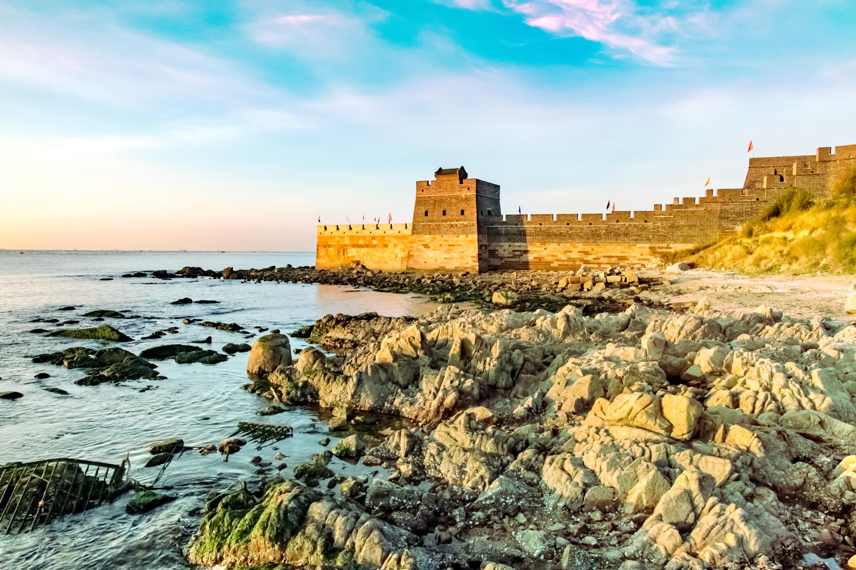
Qianxi Qingshan Guan Great Wall Located in the branch of the Yanshan Mountains The Great Wall of thousands of miles winds through the hinterland of Daqing Mountain The ancient castle is built on the platform at the foot of the mountain Hence the name, Qingshan Guan Great Wall Friends who like mountain climbing, sightseeing and photography should not miss this scenic spot with a long history and culture just tens of kilometers away from the city. 📍Detailed address: Qianxi Qingshan Guan Great Wall Scenic Area 🚉Travel strategy: About 1.5 hours drive from Tangshan city 💰: Ticket price is 40 yuan ⏳Play time: The scenic area is not too large, the whole circular tour takes about 2-3 hours ✅Must experience: The core scenic area has five functional areas: Qingshan Ancient Castle, Miaogu Mountain Villa, Qingshan Club, Biancheng Hotel, and Qingshan Cottage. It is the original flavor and antique nostalgia, it is the humanistic feelings of 'holding up a wine glass to taste the Great Wall, lying in bed to see the Great Wall, leisure and entertainment accompanied by the Great Wall'. 🌟Highlights: There are more than 220 kilometers of the Ming Great Wall in Tangshan, and the most exquisite section is the Qingshan Guan Great Wall. Here is the only preserved lifting water gate of the Great Wall, the ancient Guancheng that still stands tall after five hundred years of war, the seventy-two coupon tower with strange shapes and ingenious craftsmanship, and the eight-sided peak of the North Sky. 🏨Scenic hotel: In addition to the original hotel in the scenic area, the castle area also has antique homestays for everyone to experience. If you want to immerse yourself in the ancient city culture, you might as well give it a try. ❤Recommended reason: The overall difficulty of the Qingshan Guan Great Wall is not great, friends who love mountain climbing and photography should not miss it, of course, it is very suitable for a short trip around the family.SamanthaRobinson890|58The Qianxi
The Qianxi Lixiang Lake RV Camp is adjacent to the Daheiting Reservoir. The cabins that live on the top of the mountain get up early to see the sunrise is very beautiful. The cabin standard room can accommodate two people, with a bathroom, living room and sofa. The space is still very spacious, sleeping quiet in Henan at night. The car under the mountain can also live, there are three people living, two people living, the price is different. The water in the back of the reservoir is very beautiful. The weekend is great for bringing kids to play.Ling_See__World.3Xifengkou Underwater Great Wall ‖ Hiking Guide
More than 200 km east of Beijing lies the Panjiakou Reservoir, known as the "Little Thousand Islands," and a section of the Great Wall known as the Xifengkou Underwater Great Wall. Hiking deep into the mountains, standing on the remnants of a beacon tower, and gazing at the Panjiakou Reservoir, it's hard to imagine that a magnificent section of the Great Wall lies hidden beneath the tranquil surface. ………… ✅ Location: Shixifengkou Village, Luanyang Town, Qianxi County, Tangshan City, Hebei Province. It's over 200 km from Beijing, about a 3-hour drive. ………… 🔴 Xifengkou, known as Lulong Pass in the Tang Dynasty, is located in the eastern section of the Yanshan Mountains. A strategic pass connecting north and south, linking cities east and west, it has guarded the Central Plains and served as a gateway to the capital, making it a battleground throughout history. In the first year of the Jingtai era of the Ming Dynasty, Zou Laixue began constructing the Xifengkou Camp, later building the pass itself and the Zhenyuan Tower, calling it the New Pass. Emperor Xuanzong of the Ming Dynasty personally led an expedition through Xifengkou, defeating the Three Guards at Kuancheng. Qi Jiguang, stationed in Jizhou, reinforced the city walls and defenses, repelling enemy raids. In modern times, during the Japanese invasion of China, the 29th Army fought fiercely along the Great Wall at Xifengkou, every inch of land contested. The Broadsword March echoed throughout China. During the liberation of China, the Fourth Field Army marched towards Pingjin, using deceptive tactics and traveling light, with millions of troops passing through Xifengkou. ………… 🔵 After the founding of the People's Republic of China, the construction of the Panjiakou Reservoir brought water from the Luan River to Beijing and Tianjin. As the reservoir filled, large areas of the valley were submerged, hiding the Xifengkou section of the Great Wall underwater, unknown to many. ………… ⚪️ This is a non-scenic route, about 7.5 km one way, with a total ascent of about 700 m. It's an out-and-back trail. See Figure 13 for the route map. Starting from Xifengkou Village 1, the terrain mainly consists of unpaved mountain trails, village roads, gravel paths, and sections of the wild Great Wall, with some ridge trails. For experienced hikers, it's a relatively beginner-friendly route, with basically one major climb. However, it can be somewhat strenuous for first-time hikers. ………… ✅ Tips 1️⃣ Even though it's only the end of March, the temperature in the Beijing-Tianjin-Hebei region has soared to nearly 30°C, feeling like summer in an instant. Be prepared for sun protection. 2️⃣ Wear long sleeves and pants to protect yourself from scratches from branches and thorns along the mountain trails. 3️⃣ Bring high-calorie, compact food and 2L of water. Since this is not a scenic area, there are few places to resupply. There's only one vendor selling water and food near the beginning of the dirt trail up the mountain. Bring a plastic bag to carry your trash back down. 4️⃣ If you run out of energy towards the end, you can take a villager's boat back to the other side.EmberEon_456Xifengkou Great Wall
The Xifengkou Great Wall, located within the Panjiakou Reservoir area, is mostly submerged, with its underwater sections faintly visible, creating a unique spectacle among the Great Wall. The blend of mountains and water resembles a picturesque landscape painting, showcasing a fusion of ancient and modern civilizations. Introduction to Xifengkou Great Wall ● Construction Time: Xifengkou, known as Songting Pass during the Song and Liao dynasties, had its gate rebuilt during the Ming Yongle period and renamed Xifengkou. The construction of the pass, including walls connecting to the Great Wall, was completed in July 1452 (the third year of the Jingtai period). ● Military Significance: Xifengkou has always been a strategic transportation hub and a battleground for military strategists. The patriotic poet Lu You of the Southern Song Dynasty wrote, "In the dead of night, I suddenly cried out, dreaming of capturing Songting Pass," highlighting its military importance. In 1933, the invading Japanese army attempted to enter through Xifengkou, but were met by the resistance led by General Song Zheyuan. ● Historical Significance: The Xifengkou Great Wall, stretching approximately 50 km within Kuancheng Manchu Autonomous County, served as a vital gateway connecting central China to the northern frontier and northeastern border during the Ming Dynasty. It is renowned for its well-preserved original state, untouched by artificial restoration. Due to its strategic location, this crucial pass has been a contested territory throughout history, witnessing the Battle of Xifengkou during the War of Resistance Against Japanese Aggression. ● Recognition: In 2009, the Xifengkou Great Wall War of Resistance Relics were designated as a provincial-level patriotic education base. In January 2017, the National Development and Reform Commission included the Xifengkou Great Wall War of Resistance Relics in the "National List of Classic Red Tourism Scenic Spots." In June 2021, it was selected as a newly designated national patriotic education demonstration base. Difficulty: ★★☆☆☆ Difficulty Description: This is a non-scenic route, approximately 10 km long, with a total ascent of about 700 meters. It's an out-and-back trail with diverse terrain, starting from Xifengkou. The terrain mainly consists of wild mountain forest dirt and stone paths, country roads, gravel roads, and wilderness paths, combined with some ridge trails. Suitable for: Healthy individuals aged 10-55 with some outdoor experience. Precautions: (1) Due to recent rain and snow, all hiking activities will proceed regardless of weather conditions, except in extreme cases. Please bring rain gear and warm clothing. (2) Hiking activities may be affected by unforeseen circumstances such as flood control, which may prevent access to the mountains. In such cases, the team leader will adjust the itinerary accordingly. Please understand this situation if you participate. (3) Strict fire prevention measures are in place, and access to the mountains may be restricted. Alternative routes will be arranged if necessary. Do not bring fire sources into the mountains. (4) Please assess your physical fitness realistically. Once the hike begins, strictly follow the team leader's instructions and do not descend the mountain alone. (5) This is a purely recreational outdoor activity with no shopping stops at stores or farmhouses. (6) There are no tour guides for this activity, only a team leader to coordinate group actions. Babysitting services are not provided. Participants are expected to have a sense of teamwork and outdoor spirit, helping each other and working together to solve any problems.ANDERSON MALONEA fairyland beyond the Great Wall.
$About 200 km east of Beijing, there is a hidden paradise called Panjiakou Reservoir, also known as the "Fairyland beyond the Great Wall" and "Little Three Gorges beyond the Great Wall." This place amazed me! The water flows over the mountains, and the water above the mountains looks like a giant dragon coiling around, forming the "Panlong Lake." The unique "Underwater Great Wall" is formed by the integration of part of the Great Wall with the water. $The scenery in the lake area is picturesque: deep canyons, strange peaks, and grotesque rocks. The uncanny workmanship of nature makes this place infinitely charming. Taking a boat tour on the lake is like being in a painting, as if you are walking on the "Lijiang River in the North." $The town also has its own unique charm. The essence of the reservoir can only be reached by boat. $Recommended route: Reservoir Dam → Underwater Great Wall → Panlong Cave in the Ten-Mile Gallery → Xianju Valley. Location: Panjiakou Reservoir Water Conservancy Scenic AreaBENNETT SCHWARTZLittle Guilin beyond the Great Wall | Panjiakou Reservoir
⛰【Attraction Guide】 📍Address: Panjiakou Reservoir, Qianxi County, Tangshan City, Hebei Province 🚗Transportation: Search for "Panjiakou Reservoir Shanshui Farmhouse" 🕙Opening hours: All day 💰Ticket price: Free 🛤️Route: Ferry👉🏻Underwater Great Wall👉🏻Xifengkou👉🏻Panlong Cave👉🏻Xianju Valley 🌟Highlights: [One] Underwater Great Wall: Due to the construction of the reservoir, part of the Great Wall has been submerged, forming a unique "Underwater Great Wall" landscape. [Two] Ancient Great Wall ruins: Tourists can visit the nearby ancient Great Wall and feel the vicissitudes of history. [Three] Natural scenery: The strange peaks and clear lake water on both sides of the reservoir have formed the reputation of "Northern Three Gorges, Yan Great Wall Lijiang River". [Four] Farmhouse experience: Tourists can experience rural life in the farmhouse and enjoy nature and tranquility.321Miles~Miller$This summer, you must visit the underwater Great Wall!!!
Located in Xichengyu Village, Panjiakou Reservoir, Qianxi County, Tangshan City, there is a 'wild Great Wall' winding underwater. The scenery is beautiful, and it is known as the 'Little Guilin of Tangshan.' To climb the Great Wall, you need to take a speedboat, which costs 200 yuan per boat for about a ten-minute ride. If you want to take a boat tour, it costs 600 yuan per boat, and each boat can carry ten people. Navigate to the waterfront pier. On the way, there will be shopkeepers trying to attract customers. The price of speedboats is quite transparent, generally 200 yuan. The local farmhouses seem to have very few people, so we didn't eat there. The address is near the location. In short, it is a very beautiful and very worthwhile place to visit.TechGeekeryA paradise on earth surrounded by mountains is right beside us in Hebei
A paradise on earth surrounded by mountains is right beside us in Hebei, where you can also find a gallery that rivals the landscape of Guilin stretching over ten miles. A small boat, a clear pond, a mountain, a water, an island, a lake, all are the most beautiful gifts from nature. I really didn't expect that in Hebei, you could find such a heavenly place. The location is at the Panjiakou Reservoir in Qianxi, Tangshan. Whether you are driving on a road trip or joining a tour group, both are good choices. The scenery is truly very beautiful, so beautiful that it's hard to imagine this is in Hebei. The strangely shaped stalactites, the mysterious and interesting underwater Great Wall. At night, you can also see the crimson afterglow and the golden sunset, as beautiful as an ink wash painting. Especially in the evening, the calm lake reflects a touch of shallow gold. A gentle breeze passes by, and all around is silent. Occasionally, one or two cormorants fly by, leaving behind the footprints of all living beings. After experiencing the noisy city bustle and pressure, here you can find a quiet and peaceful corner to slowly enjoy this rare tranquilityEvelyn Hayes 234~Great Wall of China
#ChinaTravel While traveling the Great Wall of China, I was amazed and awed by this huge and amazing historical landmark. I traveled along the wall and enjoyed the magnificent scenery of the breathtaking landscape surrounding it. I climbed the stones and explored the towers along the wall, and enjoyed the wonderful views of the surrounding area. I felt contemplative and respectful of the magnificent architecture and construction techniques used to build this huge landmark, one of the Seven Wonders of the Ancient World. Visiting the Great Wall of China was an interesting and enjoyable experience as it left me with an appreciation and deep admiration for Chinese history and culture.Ayah AbdullahGreat Wall of China
#ChinaTravel My visit to the Great Wall of China was an amazing and impressive experience. The adventure began with walking the old wall to the landscape. I enjoyed walking through the corridors and exploring the towers and ancient areas. The atmosphere was full of history and culture, a harmony of natural beauty and the grandeur of human architecture. Seeing the length of the historically massive wall running along the mountain was amazing, and I added an amazing image to my memory. This visit was an opportunity to explore one of the greatest historical landmarks in the world, and the memory will live forever in my memory and be exciting.Ayah AbdullahQianxi County's Rainflower Valley
Bringing the little one to Rainflower Valley was truly worth it! The sea of shibazakura flowers is so beautiful it's intoxicating, and the children's non-powered amusement park made the little one so happy. There's also professional photography services among the flowers, capturing our family's wonderful moments. Don't forget about the exciting attractions like water jetpacks and sea lion shows! The address is in the Lavender Manor of Rainflower Valley, Qianxi County, Tangshan, Hebei. Come and experience it! 👨👩👧SUNNY GALLAGHERTo China to see the Great Wall~ 🧱
1️⃣ I went to see the Great Wall while traveling to Beijing! 2️⃣ There were always a lot of people, so it was crowded. It was hard to take pictures. ☺️ 3️⃣ And for some reason, there was a lot of urine smell, so please enjoy it only with pictures. ㅎㅎ #TravelSupportEvent #ChinaTravel #GreatWallnorhumGreat wall of china
#summerdream Great wall of china The Great Wall of China, a wonder of the world • The Great Wall of China is a wall with forts in ancient China, built to protect against invasions by the Han or Xiongnu people. • Most of the wall that stands today was built during the Qin Dynasty. • The Great Wall of China is more than 21,196 kilometers long, covering 15 provinces across the country. • The Great Wall of China was listed as a World Heritage Site in 1987. • The Great Wall of China is one of the Seven Wonders of the Middle Ages.Jomjam_anongtidaan absolute masterpiece
1. Address - Great Wall of china Highlights - an absolute masterpiece Rating - 5star 2. Address - Great Wall hike Highlights - good experience Rating - 4.5star 3. Address - Beijing Highlights - traditional cultural city Rating - 5starSABEERNo need to climb hard ✨ Great Wall Cable Car
The fact that there is a cable car on the Great Wall these days! Did you all know? It's great because you can climb it comfortably💕 Personally, I recommend taking the cable car up and walking down 🎶 Everyone, come and enjoy the Great Wall comfortably💝 ·͙⁺˚*•̩̩͙✩•̩̩͙*˚⁺⁺˚*•̩̩͙✩•̩̩͙*˚⁺⁺˚*•̩̩͙✩•̩̩͙*˚⁺ ·͙⁺˚*•̩̩͙✩•̩̩͙*˚⁺⁺˚* 🏷️ Great Wall Cable Car #Overseas Travel #China Travel수빔A place you can't miss when traveling to China, the Great Wall 😆
Among the famous tourist destinations in China, the most famous one is definitely the Great Wall of China! There is also a cable car, so it is not too hard to go up and down, which is great :) You should definitely visit it when you travel to China 💕 ゚゚・*:.。..。.:*゚:*:✼✿ ♡ ✿✼:*゚:.。..。.:*・゚゚ 🏷️ Great Wall of China #Overseas travel #China travel수빔Beijing
Beijing capital. the Great Wall is awesome it was an amazing experience I love it 🥰 #china #greatwall #greatwallofchinamouhssine aramchiThe Great Wall of China, a wonder of the world
Great Wall of China, a wonder of the world, a legend of the greatness of China #InternationalTrip #VisitChina Beijing #beijing #beijingtrip 🗺 For where we went, they divided the zones for foreign tourists and for people in China for convenience and to limit the number of tourists who will visit and accommodate no more than the quota of tourists. 🏰 As for the Great Wall of China, many people probably already know that it is one of the 7 wonders of the world, an ancient civilization that is over 20,000 kilometers long. It is also said that the greatness of the wall, along with many other stories about the grandeur of this place. Let's get to know it briefly about the Great Wall of China. Why did the ancient Chinese have to devote all their strength to make it so big? The Great Wall of China (長城) was an important strategic point during the Qin Dynasty to prevent invasions from the Han people or nomadic tribes on horseback at that time who would often invade the Chinese people along the border and were at odds with the Chinese people at that time. This wall was built before the time of Qin Shihuang. The kingdoms or states along the border built it to protect themselves. "Legend says that the Great Wall of China was built with the dragon as the prototype, the most powerful sacred animal, with the power to protect its territory." 🔆 Currently, the Great Wall of China that we see (including those that the government does not allow to be visited) is only 1/3 of the total wall. Most of it has been eroded by time and lacks proper maintenance and preservation. For those who have never been there, I would like you to try to find an opportunity to visit it at least once in your life. Because this is considered a wonder of the world made by man, which is worth visiting. If you have the chance, I hope everyone will visit it at least once. 🥴 #Waiting for the day to travel #Traveling abroadJUST GO AROUND6Great Wall
Great Wall of China 🇨🇳 … This area is secluded with minimal tourists. This part of the Great Wall is away from civilization so be careful. This area is gorgeous and amazing, one of the best experiences I had in China❤️. #beautiful #awesomepic #sevenwondersoftheworld #gorgeousSira_zn3China
Great wall in BeijingRonny MelloIf you say
If you say a tree house, you may not be fresh. You live in a chestnut garden and live on a chestnut tree. If you accidentally encounter a little squirrel stealing chestnuts, this will be a feeling. If you come, you will know ! The chestnuts of the homing tribe are very delicious, sweet and sweet, can't stop eating, and are especially good for peeling. No wonder there will be little squirrels to steal.Ling_See__World.Unfamiliar
Unfamiliar to the west, know the little cherry blossoms, there is a nice name - - Yuhua Valley. The winds of April and May have been blown, and the beautiful scenery of the east bank of the Great Heiting Reservoir is pleasant! Shiba Sakura, a beautiful but easy to deceived name, lonely in the low places swaying in the wind, a flower, a cluster, a piece, even the city flowers into the field ... never glamorous flowers, but it has become cold spring The most beautiful scenery!Domi_Lee.I just hea
I just heard that I wanted to climb this Jingzhong Mountain in the north of Tangshan. In fact, I refused a bit. It was a joke. Although the mountain is not too high, the altitude is only 610 meters, but the mountain is quite majestic and steep, with a total of 1872. Level step! Level 1872! Level 1872! The important thing is to say 3 times! Going back and forth, its not nearly 4,000 steps! However, after I heard that this seemingly inconspicuous hill was once praised by Emperor Kangxi, the title of "The World Famous Mountain", it was a strong interest in it. For Kangxi Emperor, this Jingzhong Mountain can be regarded as his blessed land forever. There is no reason for it. According to the inscriptions in the mountains, Shunzhis 16th year, Shunzhis squatting The Yuan Bu Yuan Jun, the silver and the silver two" - and the emperor is the future Emperor Kangxi. Along the 1872 steps of Emperor Kangxis Emperor Kangxis entrance to Jingjingshan, the four-story hall, the first, second and third tea sheds, the Lingguan Hall, the Chaoxian Gate and the top of the mountain Yuanjun Temple, although quite a bit of physical exertion (Kangxi Emperor should not have climbed up by himself...) But on the summit, the mountains in the distance are spread out like waves, and suddenly there is a sudden birth in the chest. "Listing the mountains and small" spirit.ZIMO.

Popular Qianxi Topics

Attractions
25 posts

Guides
10 posts

Destinations related to Qianxi
Qinhuangdao
534 posts
Chengde
291 posts
Zhangjiakou
233 posts
Post
More Recommendations
Popular Trip Moments
Xifengkou Underwater Great Wall ‖ Hiking Guide | Xifengkou Great Wall
| A fairyland beyond the Great Wall. | Little Guilin beyond the Great Wall | Panjiakou Reservoir | This summer, you must visit the underwater Great Wall!!! | A paradise on earth surrounded by mountains is right beside us in Hebei | Qianxi County's Rainflower Valley | To China to see the Great Wall~ 🧱 | Great wall of china | So close and so beautiful, head to Hebei for the weekend | an absolute masterpiece | No need to climb hard ✨ Great Wall Cable Car | A place you can't miss when traveling to China, the Great Wall 😆 | Beijing | The Great Wall of China, a wonder of the world | China
Recommended Attractions at Popular Destinations
Bangkok attraction near me | Manila attraction near me | Tokyo attraction near me | Taipei attraction near me | Hong Kong attraction near me | Seoul attraction near me | Kuala Lumpur attraction near me | Los Angeles attraction near me | Shanghai attraction near me | New York attraction near me | Shenzhen attraction near me | Osaka attraction near me | Singapore attraction near me | London attraction near me | Guangzhou attraction near me | San Francisco attraction near me | Beijing attraction near me | Macau attraction near me | Bali attraction near me | Jakarta attraction near me | Paris attraction near me | Ho Chi Minh City attraction near me | Istanbul attraction near me | Phuket attraction near me | Chicago attraction near me | Seattle attraction near me | Toronto attraction near me | Orlando attraction near me | Cebu attraction near me | Chiang Mai attraction near me
Popular Restaurants in Qianxi
迁西渔丰街莱真牛烤肉总店 | 肯德基(迁西店) | 民政饭店 | 聚仙山庄 | 伊尔曼都自助烤肉火锅(盛世峰景店) | 华莱士·全鸡汉堡(迁西店) | 十三太煲私房菜(丰泽店) | 东北农家饭庄(喜峰中路店) | jiale | Jiutongwang | YING SHANG FA SHI TIE BAN SHAO | 碰碰凉(一幼店) | 合顺家常菜(盛世峰景店) | 袁记串串香(迁西店) | 老北京铁锅柴鸡(迁西店) | Mixuebingcheng (qianxi'er) | 一品味羊汤(栗乡广场店) | 干锅鸭头 | 迁西哆点甜牛乳冰室 | 小河边酸菜鱼 | 山西饺子面食馆(津西路店) | 蜀滏火锅店 | 华莱士·全鸡汉堡(金桥店) | 烘焙假日(丰泽店) | 青瓦台炭火烤肉 | 斯利美甜品(凤凰东街店) | 国王摩点(商贸城店) | 金三顺紫菜包饭(千玺店) | 丽都饼屋(喜峰路阳光商城店) | 世华正宗糖炒板栗
Popular Ranked Lists
Top 10 Local Restaurants in Zhongwei | Top 10 Local Restaurants in Liverpool | Popular Luxury Hotels Near Kongsberg | Top 6 Best Things to Do in Bijie | Top 8 Best Things to Do in Qujing | Top 9 Local Restaurants in Liuzhou | Popular Local Restaurants in Huanggang | Popular Luxury Hotels Near Goslar | Top 3 Best Things to Do in Chuxiong Prefecture | Popular Premium Hotels in Palakkad | Popular Luxury Hotels Near Fell Lapland | Top 10 Local Restaurants in Guam | Top 9 Best Things to Do in Xuancheng | Top 10 Local Restaurants in Enshi City | Popular Best Things to Do in Liancheng | Top 4 Best Things to Do in Nanyang | Popular Luxury Hotels in Malargue | Top 5 Best Things to Do in Suqian | Popular Premium Hotels in Grad Korcula | Top 7 Best Things to Do in Benxi | Top 4 Best Things to Do in Cixi | Top 9 Local Restaurants in Datong | Top 5 Local Restaurants in Chengde | Popular Luxury Hotels in Paradise Island | Popular Luxury Hotels Near East Brunswick | Top 10 Local Restaurants in Tonglu | Top 10 Local Restaurants in Nan'ao | Popular Best Things to Do in Ankang | Popular Luxury Hotels in Malargue Department | Top 9 Local Restaurants in Mianyang
Payment Methods
Our Partners
Copyright © 2025 Trip.com Travel Singapore Pte. Ltd. All rights reserved
Site Operator: Trip.com Travel Singapore Pte. Ltd.
Site Operator: Trip.com Travel Singapore Pte. Ltd.