https://ae.trip.com/moments/destination-khiri-mat-1448347/
2025 Khiri Mat Travel Guide: Must-see attractions, popular food, hotels, transportation routes (updated in June)
All Moments About Khiri Mat
3 kilometers but very steep!! Khao Luang Sukhothai
#Hiking Hiking Khao Luang Sukhothai is only 3.7 kilometers away, but it's super steep, everyone. Can a beginner walk it? If you want to try, you can walk, but you'll definitely get tired. Let's go to other easier mountains and then walk at Khao Luang Sukhothai. There are 4 peaks: Khao Phra Chedi, Khao Phuka, Khao Phra Mae Ya, and Khao Narai. Khao Luang Sukhothai is a very beautiful place with many viewpoints. I recommend staying for a night or two. 📌Khao Luang Sukhothai ⭐️Personal satisfaction: 🌟🌟🌟🌟🌟 #100 ways to travel #Nature attractions #Beautiful places to take pictures #Rainy season attractions #Camping spotsbenztiful3☕ Prom's Cafe & Eatery
#Secret shop 💯 Prom's Cafe & Eatery is a restaurant that perfectly combines the atmosphere of a cafe and a restaurant. It is decorated in a stylish way. There are many beautiful photo spots. It serves both savory and sweet dishes, drinks, and homemade bakery. It is suitable for relaxing, socializing, or stopping by to recharge during the day. 📍Sukhothai ⏰09:00-19:00 #Thailand #Travel #Onedaytrip #Family trip #Good atmosphere #Thai travel in Thailand #Travel in Thailand #Travel along the way #Cafe review #Beautiful cafe to share #Life addicted to cafes #Must-visit cafes #Cafes for taking beautiful photos #Trip free accommodation #Trip discount #100 ways to travelBrightTrip11📌 Khao Luang View Cafe, a secret shop with a natural view
#Secret shop 💖 View Khao Luang Cafe is a cafe with a good atmosphere and beautiful views, just as its name suggests. It is located amidst nature. There are many beautiful photo spots. It is suitable for relaxation. The drinks taste good. There are many menus to choose from, including coffee, tea, and fruit juices. The price is not expensive. There are cakes and bakery items to choose from with drinks. The service is friendly. Overall, it is impressive. It is suitable for those who like cafes with a natural atmosphere. 📍T. Na Cheng Khiri, A. Khiri Mat 64160 🚗There is a parking lot. #Thailand #Travel #Onedaytrip #Family trip #Good atmosphere #Thai travel in Thailand #Travel in Thailand #Travel along the way #Cafe review #Beautiful cafe to tell #Life is addicted to cafes #Must-visit cafes #Cafes that take beautiful photos #Trip gives away free accommodation #Trip gives away discounts #100 ways to travelBrightTrip11🌰HOUSE MERGE COFFEE SLOWBAR
#tripแจกโรงแรมฟรี ☕HOUSE MERGE COFFEE SLOWBAR is a minimalist-style cafe located in Si Samrong District, Sukhothai Province. The shop is a small white house decorated in black and white tones and wooden furniture, giving it a warm and relaxing feeling. The shop is surrounded by nature, surrounded by various trees. The overall atmosphere feels like a cafe abroad. 🍶The shop's drink menu has a variety of both coffee and non-coffee menus, especially the Slow bar menu with a large selection of coffee beans, suitable for coffee lovers who love to truly enjoy the taste of coffee. There are also homemade pastries and bakery items available. 🌭The highlight of HOUSE MERGE COFFEE SLOWBAR is the quiet atmosphere, perfect for relaxing and escaping the hustle and bustle. In addition, the taste of the drinks and pastries is delicious. It is another shop worth visiting if you have the chance to visit Sukhothai Province. 📍The Bas Coffee, T. Ton Don 📍A. Khiri Mat, Sukhothai Province 64160 ⏰09:00-17:00 hrs. 🚗Parking available 💰50-100 baht #IndyTrip #thailand #travel #onedaytrip #cafe review #beautiful cafe share #cafe life #must visit cafe #beautiful photo cafe #Trip free accommodation #post for luckIndy Trip13🥤The Bas Coffee
#VisitSecondaryCity 🍯The Bas Coffee, a small cafe in Khirimat District, has more than you think and is ready to serve from the heart. Coffee lovers, the shop has something for you to try. I would like to recommend the pizza, it is very delicious. I must say that you must try it. The burgers here are also delicious. There are also new menus, fresh every day, offered to eat all the time. Make it yourself, brew it yourself. Come and try it. 📍The Bas Coffee, T. Ton Don 📍A. Khirimat, Sukhothai Province 64160 ⏰09:00-17:00 hrs. 🚗There is parking 💰50-100 baht #IndyTrip #thailand #travel #onedaytrip #cafe review #beautiful cafe to tell #cafe life #must-visit cafe #beautiful photo cafe #Trip free accommodation #post to receive luckIndy Trip12☕PROM'S CAFE & EATERY
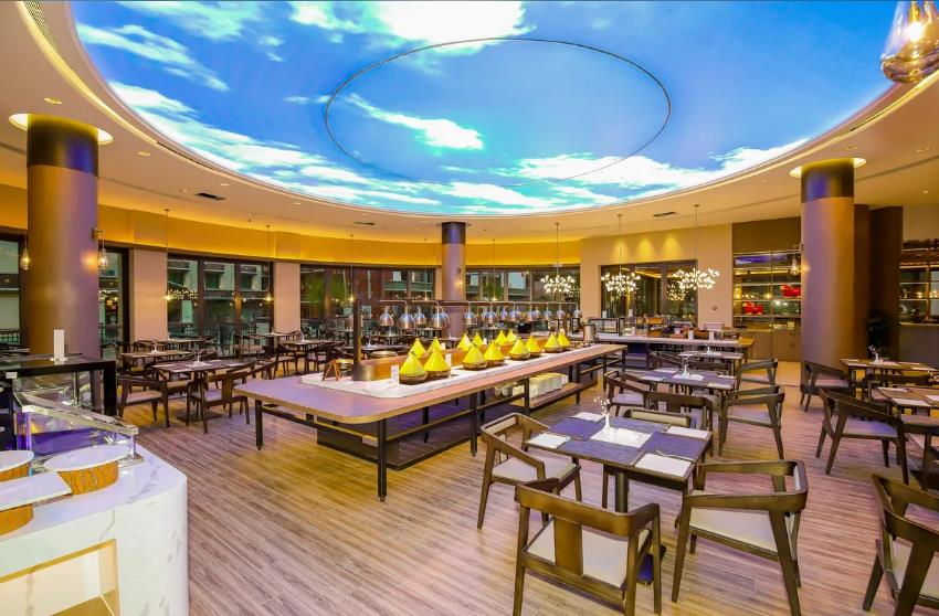
#VisitSecondaryCities 🍷PROM'S CAFE & EATERY is a classic restaurant and cafe in Sukhothai Province. It stands out with its vintage-style decoration mixed with modernity. It has a variety of menus, both Thai and international, with delicious tastes, especially the recommended menu, stir-fried noodles with cha-om and shrimp, which everyone loves. There are also many drinks and desserts to choose from. 🍸Not only the delicious taste of the food, the atmosphere in the shop is warm and friendly, suitable for relaxing, sipping coffee, eating desserts, or socializing with friends. There are also beautiful photo corners to capture memorable moments. For anyone passing through Sukhothai, don't forget to stop by and try the deliciousness at PROM'S CAFE & EATERY. I guarantee that you will not be disappointed. 📍115 Ton Don, Ton Don Subdistrict 📍Khiri Mat District, Sukhothai Province 64160 ⏰08:30-15:30 hrs. ☎️082 405 8424 🚗There is parking 💰80-100 baht #IndyTrip #thailand #travel #onedaytrip #cafe review #beautiful cafe to share #Cafe life #Must-visit cafes #Beautiful photo cafes #Trip free accommodation #Post to receive luckIndy Trip12A beautiful national park where nature and history come together. Come experience the charm of Ramkhamhaeng.
#AbsolutelyFreeTrip Ramkhamhaeng National Park is where Thailand's rich nature and history come together. Here you can find beautiful forests, clear rivers, and diverse flora and fauna. Visitors can relax in nature and explore historical ruins. You can enjoy the scenery in every season, especially in the rainy season, when the greenery is vibrant and soothing. A great tourist destination where you can experience local culture and history while walking the trails maintained for nature conservation. Ramkhamhaeng National Park is an ideal spot for nature lovers and history buffs. #thailandtripAom_92Rainbow Waterfall, Sukhothai
Sai Rung Waterfall, Ramkhamhaeng National Park - Ramkhamhaeng National Park, Khiri Mat District, Sukhothai Province is a waterfall that will have water only in the rainy season. The amount of water depends on the amount of rainfall. The waterfall has 4 levels in total. The walking distance from the tourist service center, park ranger unit to level 4 is approximately 1200 meters.TravelNoteBehindTheLens#GetDiscou
#GetDiscountNotDependingOnLuck #KhaoLuangSukhothai Khao Luang is the highest peak in Sukhothai Province. It is located in Ramkhamhaeng National Park. At 1,200 meters above sea level and surrounded by abundant nature, Khao Luang is a popular destination for travelers who want to experience a fun and challenging nature trail. Khao Luang consists of 4 peaks with different unique beauty: Khao Narai Peak, a viewpoint for the sunrise in the morning Khao Phra Chedi Peak, a viewpoint for the sunset Khao Phra Mae Ya Peak, and Khao Phu Ka Peak, suitable for admiring the green nature Khao Luang is not only charming with beautiful scenery and spectacular sunset views, but also with a variety of natural areas of forests and many conservation plants. It is also a popular nature trail that attracts both adventurers and novice mountain climbers. Location of Khao Luang Sukhothai Khao Luang Sukhothai is part of Ramkhamhaeng National Park, covering Ban Dan Lan Hoi and Khiri Mat districts, Sukhothai Province. It is approximately 30 kilometers from Sukhothai city. It can be easily reached by car or public transportation. Khao Luang Travel Route The Khao Luang hiking route It is not too difficult for beginners to hike, but it comes with excitement and challenge, earning it the nickname “The Mountain of the North” because it is a long and steep mountain trail that continues to climb to the top, covering a distance of about 3.7 kilometers with a slope of 45-90 degrees and is a closed forest trail with no dangerous ravines. In total, it takes about 3-4 hours to walk, depending on your physical condition and weather conditions during the journey. Walking up a steep path of almost four kilometers requires a lot of energy, so all tourists should eat a moderate amount of food to fill up their stomachs, not too full, and carry water to sip regularly, such as a 1.5-liter water bottle or a water bottle to refill along the way at rest stops.AomsomKhao Luang Sukhothai, Ramkhamhaeng National Park
#Travel to save the world Review: Khao Luang Sukhothai under Ramkhamhaeng National Park Sukhothai Province Khao Luang Sukhothai is located in Ramkhamhaeng National Park, Khiri Mat District, Sukhothai Province. It is the highest mountain in the province, with the highest peak at approximately 1,200 meters above mean sea level. It is a popular ecotourism destination for adventurers and nature lovers. Characteristics of the route and tourist activities The hiking trail to Khao Luang is approximately 3.7 kilometers long. The route is quite steep, with some sections averaging 45 to 90 degrees. It takes about 3–5 hours to walk up, depending on the physical condition of the tourist and the weather at that time. Along the way, tourists will experience the abundant nature and beautiful scenery, especially when reaching the top of the mountain, where they can see a panoramic view of the surrounding mountains. Important viewpoints include Khao Narai, which is suitable for watching the sunrise, and Khao Phra Chedi, which is suitable for watching the sunset. Facilities The park provides a tent site near the top of the mountain, with basic facilities such as toilets, resting areas, and a convenience store selling dried food, drinking water, and camping equipment. Tourists can rent tents and bedding from the park at their convenience. Recommendations for visiting For safety and convenience in traveling, tourists should prepare their bodies, wear hiking shoes, and carry enough drinking water, at least 1.5 liters per person, especially in the summer when the weather is quite dry and hot. Avoid hiking during the rainy season because the path may be slippery and risky. Khao Luang Sukhothai is therefore considered one of the important eco-tourism destinations in the North. With its distinctive topography, challenging hiking, and beautiful scenery, it is suitable for tourists looking for a sustainable and impressive nature experience. We recommend it.ยายมีและยายมอย1🏛️🌿 SUKHOTHAI WEEKEND ESCAPE: Where Ancient Kingdoms & Lotus Ponds Await!
#springitinerary "Step back in time at Thailand's first capital" WHY SUKHOTHAI? ✅ UNESCO World Heritage ruins without the crowds of Ayutthaya ✅ Cycling through history among 800-year-old temples ✅ Authentic local life beyond the tourist trail 🚍 GETTING THERE From Bangkok: 1hr flight to Phitsanulok (1,800฿) + 1hr transfer By Bus: 6hrs from Mo Chit (450฿) direct to New Sukhothai Pro Tip: Rent a bicycle (50฿/day) to explore the historical park 🌅 DAY 1: Temple Hopping & Local Flavors ☀️ MORNING 6:30 AM Sukhothai Historical Park Sunrise Enter at dawn to see Wat Mahathat glow golden (100฿ entry) Must-see: The iconic walking Buddha at Wat Si Chum 9:00 AM Breakfast at Coffee Cup Try Khao Tom (rice soup) with local herbs 🏺 MIDDAY 11:00 AM Sangkhalok Museum Discover ancient Thai ceramics (50฿ entry) 1:00 PM Lunch at Jayhae Restaurant Order Sukhotai noodles (special thin rice noodles) 🌇 EVENING 4:00 PM Wat Traphang Thong Temple on an island reached by bamboo bridge 7:00 PM Night Market by Yom River Try Gai Yang (grilled chicken) with Sukhothai's special sauce 🌄 DAY 2: Countryside Adventures 🌄 MORNING 7:00 AM Ramkhamhaeng National Park Hike to viewpoint (3km) overlooking the ancient city 9:30 AM Local Pottery Village (Ban Hat Siaw) Make your own Sangkhalok-style ceramic 🚲 AFTERNOON 12:30 PM Cycling the Lesser-Known Zones Explore Northern Zone temples (quieter but equally stunning) 3:00 PM Wat Saphan Hin Hilltop temple with panoramic views (best for sunset) 🌙 EVENING 6:00 PM Poo Restaurant Riverside dining with local dishes 💰 BUDGET (Per Person) Accommodation: 400-1,200฿/night (stay near the park!) Food: 250฿/day (local eateries are cheap & delicious) Activities: 300฿ (bike rental + park fees) 💡 INSIDER TIPS: Visit November-February for cool mornings Hire a guide (200฿/hr) to understand the history The Saturday Night Market is bigger with more food options WHY WE LOVE IT: "Sukhothai offers Thailand's most magical blend of ancient wonder and peaceful countryside vibes. It's history you can touch, taste, and cycle through!" 📸 INSTAGRAM SPOTS: Sunrise at Wat Mahathat The giant Buddha at Wat Si Chum Lotus ponds reflecting ruined temples Pro Tip: The Western Zone requires separate entry but has stunning forested ruinsSonnySideUpEscape the heat and see the fog at Khao Luang Sukhothai
#Summer Destination Khao Luang Sukhothai: A Light Adventure Feel, Exciting for Hikers (Bangkok Edition) ⛰️👟✨ Who said Sukhothai only has historical parks? Let me tell you, you were wrong! On our latest trip, we went to "Khao Luang Sukhothai" and I would like to give it another destination that new trekkers or anyone who wants to experience nature without being too brutal must come to. * The trail is not brutal, but you will sweat: The hiking trail here is not so difficult that you have to climb cliffs, but it is challenging enough to work hard and sweat just right. It feels "tiring but fun", do you understand? * Million-dollar views, no need to filter: Walking up to each point, the view is beautiful and screams! You can see the panoramic view of Sukhothai, the mountains are intricate, the sky is so wide, it heals your heart to the max. You can take pictures from any angle and they will look great without having to edit much. * Authentic nature therapy: Both sides of the path are full of trees, grass, the sound of birds chirping, and the fresh air is really good for your lungs and heart. For those whose lives are glued to the screen, hiking here is a way to detox yourself with nature therapy. Things to prepare (city style, focus on convenience): * Sneakers: A good pair that is comfortable to wear and easy to walk in. Most importantly! * Clothes: Breathable, easy to dry, no need to be too fashionable, focus on being adventurous * Drinking water: Very important! Recharge along the way * Hat, sunglasses, sunscreen: Don't underestimate your skin in the strong sun * Mosquito repellent: Uninvited companion * Camera/mobile phone: Capture memorable moments * A heart ready to embrace nature: This is more than enough! #KhaoLuangSukhothai #Hiking #SukhothaiTravel #UnseenThailand #TrekkingThailand #NatureLover #Hiking #OneDayTrip #Camping #NatureTravelพลอยไปไหนMother Goddess Cave
Phra Mae Ya Cave is located in Ramkhamhaeng National Park, Khiri Mat District, Sukhothai Province. It is a cliff shelter and is the place where the idol was found. Sukhothai people believe that it is the idol of Nang Sueang, the consort of King Sri Indrathit and the mother of King Ramkhamhaeng the Great. It has now been brought to be enshrined at the Phra Mae Ya shrine next to Sukhothai Provincial Hall and a replica has been built and enshrined at Phra Mae Ya Cave.TravelNoteBehindTheLens“Khao Luang Sukhothai, if you don’t come, it’s a mistake!
#HikingTrip This was our first hiking trip, which started with excitement and readiness (or so we thought). But it turned out that our shoes and bags did not support us at all! Plus, the porters we booked were full, so we had to carry our heavy bags up the mountain by ourselves. My heart was shaking, but my legs had to go! The route up Khao Luang is considered brutal. It took 4 hours with steeper paths than we had dreamed of. My legs were almost exploding. But all the tiredness disappeared when we reached the top of the mountain because the view was amazing! There were many viewpoints, beautiful from every angle until we forgot about our fatigue. The weather was great. The park officers took good care of us. For those who are adventurous, are quite fit, or want to try a new experience, you have to come and prove it for yourself! Khao Luang Sukhothai is waiting for you to challenge us!” #Khao Luang Sukhothai #Hikingหนีงานเที่ยวฉ่ำ1Once in a lifetime, conquer Khao Luang Sukhothai
Khao Luang is located in Ramkhamhaeng National Park, Khiri Mat District, Sukhothai Province, 1,200 meters above sea level, approximately 36 kilometers from Sukhothai city. The park opens at 5:30 a.m. Within 2 days and 1 night, you can walk in a circle and visit all the spots. Check-in points on Khao Luang Khao Phra Chedi Khao Phuka Khao Phra Mae Ya Pha Narai Pha Chom Prang Khao Luang Sukhothai is known as a steep, steep, really steep mountain. Many people are afraid that they will not be able to climb it. Listen to your body, walk slowly, rest when you are tired, and continue walking when you are not tired. People who do not exercise often can walk. In no time, you will arrive. It takes about 4 hours to walk up and about 2 and a half hours to walk down. Enjoy the view of the mountain, trees, sky, and beautiful scenery in 360 degrees from morning to night. At the park office, there are single-family houses available. Tent camping area with toilets, restaurants and tourist service centers....travel comfortably without any difficulty #hiking trip #review of natural attractions #visit national parks #Ramkhamhaeng National Park #Khao Luang Sukhothai #places to visit in Sukhothai #natural attractions #beautiful places to take pictures #tent camping spotsน้ำทะเล สีฟ้าครามSukhothai Attractions
Besides the famous Sukhothai noodles, another well-known spot is Khao Luang Sukhothai. The mountains here are layered and stretch as far as the eye can see. I once saw them from an airplane while flying from the north to Bangkok. From above, you can see vast forests, making me realize that Thailand still has a lot of untouched nature. Sukhothai is one of those places where you can still experience natural beauty.Travelharderrr1The Milky Way is visible to the naked eye🌌
Who would have thought that we could see the Milky Way with the naked eye? At first, we thought that the Milky Way had to be viewed through a telescope. But we had to look in a large enough place. And that night, we had to make sure that there were no clouds. If it rained, we might not be able to see it. We came in the summer and the night was dark, so we could see it very clearly. The place we went to see was on the mountain at Khao Luang Sukhothai. #tripแจกโรงแรมฟรีTravelharderrrNo matter what, Thai forests are beautiful | Khao Luang Sukhothai.
This is a famous mountain in Thailand, and there are many well-known places, and one of them is here. It ranks in the top 1-10 of Thai forests that are easy to hike for beginners or amateurs who are just getting into this field. Many people like it here and come back many times because it's not only easy to walk, but also offers a lot of conveniences. You don't need to carry a lot of camping gear because everything is provided here. Plus, the view is as beautiful as any other mountain in Thailand.Travelharderrr1I love the forest, I love the mountains, I love Khao Luang Sukhothai.
This place is my top choice because it's easy to get to and the hike isn't as difficult as you might think. However, my legs did get a bit sore due to the steep path straight up the mountain. There's no detour around the mountain; you have to push yourself up. Along the way, there are bamboo poles to hold onto, and if you don't have a walking stick, there are some available. I recommend using two poles like walking sticks because they help a lot with support.Travelharderrr1Enjoy the Sea of Mist at Khao Luang Sukhothai
Sukhothai is a very relaxing province. If you ask what the city has to offer, it has an ancient city that is like a park where you can learn about historical sites from the past. There are also tourist attractions such as hiking trails and the famous Sukhothai noodles, which are popular for their long beans. We already love it, so this is another province we enjoy visiting.Travelharderrr1The Magnificent Mountain in Thailand: Khao Luang Sukhothai
This mountain is renowned for its steepness. Here, you can find services providing food, water, and even tents or sleeping pads. Everything is available, so you don't need to bring anything with you. The night air here is also very pleasant. Due to its height and darkness, stargazing at night is a popular activity. You can lie down and watch shooting stars all night long.Travelharderrr1Khao Luang Sukhothai view, a popular camping spot🏔️🌳
One of the highlights of the camping site at Khao Luang Sukhothai that many people don't want to miss and can't miss is Khao Luang. There are 2 main Khao Luang locations: Khao Luang Sukhothai and Khao Long Nakhon. Today, we came to Sukhothai, which is not too far from Bangkok. You can still travel there by yourself without a guide. We have to register at the bottom of the mountain first, and then we can go up and set up camp. Let's say that it is another place that is easy to come to and you can come with your friends. #tripแจกโรงแรมฟรีTravelharderrr1The Steepest Hiking Trail in Thailand | Sukhothai
Sukhothai is a province that doesn't have many tourist attractions. We often travel but don't really know where to go in this province. However, for trekking enthusiasts, this place is well-known for Khao Luang Sukhothai, which is very steep. We have to climb straight up with the help of ropes, and there are hardly any flat paths.Travelharderrr1Watch the sunset at Khao Luang Sukhothai🏔️
The view here is quite high, about a thousand meters above sea level, but it is on the highest peak of the mountain, so there is nothing to block the sunset. We can see both the sunrise and sunset in the same place. It is worth it to see both views here. I recommend everyone to come to this mountain. And most importantly, it is not very difficult to walk up, but it requires a lot of energy because it is quite steep. #tripแจกโรงแรมฟรีTravelharderrr1It's the best thing ever.
Walking up is already difficult, but going down is even more difficult🤣Sornxxx1Set up a tent at an altitude of 1200m above sea level 🏕️
The tent site that we will recommend today is located on Khao Luang Sukhothai. You have to walk up a short distance, just over 3 kilometers, but it is quite steep. The path is not difficult. There are signs along the way. You can walk by yourself without hiring a guide. We spent 2 days and 1 night. On the first day, we set up a tent and stayed there. We saw both the sunset and the sunrise. There are separate male and female bathrooms up there. It is convenient and the weather is not too cold. It is cool. If you don't bring your own tent, you can rent it for 225 baht per night. You have to book in advance when you register. #Tent sitePia Patrisha1The sun sets at Khao Luang Mountain
#Sunset #100TravelTips 🌞 Sunset viewpoint at Khao Luang 📍Address: Khao Luang is located in Ramkhamhaeng National Park, Na Choeng Khiri Subdistrict, Khiri Mat District, Sukhothai Province 🗓️Travel planning: This trip takes 2 days and 1 night because we will have to walk up to Khao Luang 🧗 Distance 3.7 km. But it may take up to 6 hours. 🚶 In the evening, we will have to walk from the tent to the sunset viewpoint. 🏖️ Environment: It is a stone field. Find a place to sit and watch the sunset. We will be at a high angle. 🌞 You will see the sun slowly disappear. The orange light is very beautiful. After that, you will have to hurry back immediately because it will get dark and cold very quickly.ไป ไหน ดี4Adventures in the North for Kids.
It was a very spontaneous trip, but so much fun. I really enjoyed this trip. I rushed to finish my work, got on the plane, and then rented a motorcycle to drive up to Khao Luang to camp. I got to enjoy the misty atmosphere and the cool breeze. It was delightful to savor grilled pork and local food. The next day, I went paragliding, which was an amazing experience. The best ever. And I went alone too, I'm so brave. Another day was spent rock climbing, which was incredibly beautiful. Nature is truly wonderful. The paths were easy to walk. Another day was spent wandering around the town.A’Namfon Phuket2

Popular Khiri Mat Topics

2025 Recommended Attractions in Khiri Mat (Updated June)
26 posts

2025 Recommended Guides in Khiri Mat (Updated June)
17 posts
2025 Recommended Restaurants in Khiri Mat (Updated June)
5 posts

Destinations related to Khiri Mat

2025 Bangkok Travel Guide: Must-see attractions, popular food, hotels, transportation routes (updated in June)
42792 posts

2025 Seoul Travel Guide: Must-see attractions, popular food, hotels, transportation routes (updated in June)
30234 posts

2025 Tokyo Travel Guide: Must-see attractions, popular food, hotels, transportation routes (updated in June)
21033 posts
Post
More Recommendations
Popular Trip Moments
A beautiful national park where nature and history come together. Come experience the charm of Ramkhamhaeng. | Rainbow Waterfall, Sukhothai | Khao Luang Sukhothai, Ramkhamhaeng National Park | 🏛️🌿 SUKHOTHAI WEEKEND ESCAPE: Where Ancient Kingdoms & Lotus Ponds Await! | Escape the heat and see the fog at Khao Luang Sukhothai | Mother Goddess Cave | “Khao Luang Sukhothai, if you don’t come, it’s a mistake! | Once in a lifetime, conquer Khao Luang Sukhothai | 3 kilometers but very steep!! Khao Luang Sukhothai | Sukhothai Attractions | The Milky Way is visible to the naked eye🌌 | No matter what, Thai forests are beautiful | Khao Luang Sukhothai. | I love the forest, I love the mountains, I love Khao Luang Sukhothai. | Enjoy the Sea of Mist at Khao Luang Sukhothai | The Magnificent Mountain in Thailand: Khao Luang Sukhothai | Khao Luang Sukhothai view, a popular camping spot🏔️🌳 | The Steepest Hiking Trail in Thailand | Sukhothai | Watch the sunset at Khao Luang Sukhothai🏔️ | ☕ Prom's Cafe & Eatery | 📌 Khao Luang View Cafe, a secret shop with a natural view | It's the best thing ever. | Set up a tent at an altitude of 1200m above sea level 🏕️ | The sun sets at Khao Luang Mountain | 🌰HOUSE MERGE COFFEE SLOWBAR | 🥤The Bas Coffee | ☕PROM'S CAFE & EATERY | Adventures in the North for Kids. | Stepping on clouds, walking through the mist at Khao Luang Sukhothai
Recommended Attractions at Popular Destinations
Attraction near Bangkok | Attraction near Manila | Attraction near Tokyo | Attraction near Taipei | Attraction near Hong Kong | Attraction near Seoul | Attraction near Kuala Lumpur | Attraction near Los Angeles | Attraction near Shanghai | Attraction near New York | Attraction near Shenzhen | Attraction near Osaka | Attraction near Singapore | Attraction near London | Attraction near Guangzhou | Attraction near San Francisco | Attraction near Beijing | Attraction near Macau | Attraction near Bali | Attraction near Jakarta | Attraction near Paris | Attraction near Ho Chi Minh City | Attraction near Istanbul | Attraction near Phuket | Attraction near Chicago | Attraction near Seattle | Attraction near Toronto | Attraction near Orlando | Attraction near Cebu | Attraction near Chiang Mai
Popular Restaurants in Khiri Mat
Popular Ranked Lists
Popular Must-Visit Restaurants in Ho Chi Minh City | Popular Must-Visit Restaurants in Tokyo | Popular Best Things to Do in Changsha County | Popular Best Things to Do in Daofu | Popular Must-Visit Restaurants in Barcelona | Popular Best Things to Do in Wudalianchi | Popular Premium Hotels in Valle de Bravo | Popular Premium Hotels in Mayminsky District | Top 19 Local Restaurants in Singapore | Top 4 Best Things to Do in Zhaotong | Popular Must-Visit Restaurants in Bruges | Popular Must-Visit Restaurants in London | Popular Best Things to Do in Suifenhe | Popular Luxury Hotels in Tegernsee Lake | Popular Best Things to Do in Neijiang | Popular Must-Visit Restaurants in Athens | Popular Best Things to Do in Jiaozuo | Popular Luxury Hotels in Menorca | Popular Must-Visit Restaurants in Bali | Popular Best Things to Do in Xiji | Popular Must-Visit Restaurants in Kyoto | Popular Best Things to Do in Daguan | Popular Premium Hotels in Shan | Popular Premium Hotels Near Sancti Spiritus | Popular Best Things to Do in Wuzhishan | Top 10 Local Restaurants in Dengfeng | Popular Must-Visit Restaurants in Sydney | Popular Premium Hotels Near Trinidad | Popular Best Things to Do in Gongcheng | Popular Premium Hotels in Sylt Ost
Payment Methods
Our Partners
Copyright © 2025 Trip.com Travel Singapore Pte. Ltd. All rights reserved
Site Operator: Trip.com Travel Singapore Pte. Ltd.
Site Operator: Trip.com Travel Singapore Pte. Ltd.